


Cyclogenesis is the origin of a tropical cyclone (TC). Since the cyclogenesis component of the AIR models for Atlantic Basin hurricanes was first developed, statistical modeling and hurricane science have seen exciting developments. In the realm of statistics, steady increases in cheap computing power have facilitated modeling strategies for phenomena that evolve in both space and time. On the science side, increasingly available high-resolution data sets have provided a clearer picture of environmental influences on TC formation. Given these advances, we set out to develop an explicitly space-time and environmentally-driven representation of tropical cyclogenesis.
To be considered a success, the new model would have to mimic the large-scale patterns of historical TC genesis in space and time over many seasons as well as the robust, time-tested spatially based model currently embedded in the AIR Atlantic Basin catalog. We also hoped to add value by simulating cyclogenesis response to transient variations in the local environment within seasons.
Our underlying working hypothesis is that seeding simulated cyclones in environments that could realistically support the birth of a storm will set a foundation for improved physical consistency across the lifetime of stochastic storms whose evolution is modeled conditional on their large-scale environments.
The New Modeling Approach
It has long been recognized that TC genesis is associated with a specific combination of environmental conditions working in concert. During the last four decades, predictors used in statistical models for the simulation of monthly TC genesis (and for real-time genesis forecasting) have been developed through a number of studies. The problem we explored differed from these studies, however, because we wanted to build a cyclogenesis simulator that ties TC formation to a specific realization of the atmospheric environment at fine spatial and temporal scales. In our new model, the probability of TC genesis at any location and any day in the Atlantic Basin is modeled in two pieces:
|
Prob(TCG)=SPTM+f(Env)
|
|
|---|---|
| Prob(TCG): | Probability of TCG for a given latitude, longitude, day and year |
| TCG: | Tropical Cyclone Genesis for a given latitude, longitude, day and year |
| SPTM: | Space-Time Mean for a given latitude |
| f(Env): | Function of the Environment for a given latitude, longitude, day and year |
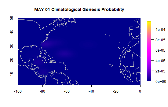
The first term represents the expected pattern across space and the hurricane season in any year. In other words, it describes the mean seasonal climatology of cyclogenesis. This “Space-Time Mean” (SPTM) term was constructed by the smoothing of the historical genesis counts over all years since 1950 in each 0.5⁰ x 0.5⁰ x 1-day latitude-longitude-calendar day grid cell. This space-time smoothing is a natural extension of that used to build the current AIR model of cyclogenesis. This empirically based term is nonparametric, meaning it is not based on the assumption of any particular probability distribution. Once computed, the values of the SPTM term remain constant for any latitude-longitude location for any given year. This term is illustrated in Figure 1, in which areas of relatively high mean probability are highlighted in bright magenta. The animation illustrates the well-known seasonal trends in the spatial distribution of North Atlantic Basin cyclogenesis. Early in the season, storms start to form close to the coast of North America; toward the peak of hurricane season, more TCs form in the “Main Development Region” off the coast of West Africa; finally, as the season concludes, the last storms tend to form toward the west side of the basin again.
The second term parameterizes deviations from the mean climatological behavior caused by the environment. Our candidate predictors, taken from our literature review, included combinations of vertical wind shear, absolute vorticity, relative humidity, and sea surface temperature (SST), all of which are mechanistically linked to cyclogenesis.
- Warm SST and high humidity in the mid-levels of the atmosphere provide a developing storm with the needed energy and moisture to sustain the rising of warm moist air from the surface to upper levels (e.g., to create deep convection).
- Absolute vorticity is the atmospheric spin needed for the storm to grow and organize.
- Weak vertical wind shear allows the growing storm to preserve its structure, and hence, increases its chance of intensifying into a TC.
We explored the presence and absence of historical cyclogenesis events as a statistical response to combinations of these potential predictors. We found that our seasonal SPTM term already ruled out regions of insufficiently warm surface water. While SST thus did not add information, the other three variables were effective predictors of genesis, and so contribute to our second model term.
Figure 2 shows the other three environmental predictor fields over the course of a certain year, which gives a sense of their daily variability. In the bottom of the left panel, one can see pockets of moist air (dark blue), an aiding factor to cyclogenesis, propagating from east to west near the equator. During the late spring through fall, pockets of dry air (white), which may inhibit cyclogenesis, are visibly propagating off the west coast of Africa from the Sahara Desert. In the center panel, the jet stream flowing from west to east in the mid-latitudes over North America is one notable area of high shear (dark green). That feature contrasts with the short-lived areas of low shear (white) that are more agreeable to TC formation. In the rightmost panel, one can see African Easterly Waves producing high vorticity during the peak of hurricane season, a common source of spin that can spark TC formation in the Main Development Region.
The daily variations of these environmental ingredients add fine-scale structure to the climatological probabilities in our genesis model. The fields we show here are derived from reanalysis data, the closest approximation scientists have available to the true historical space-time fields of humidity, shear, and vorticity.
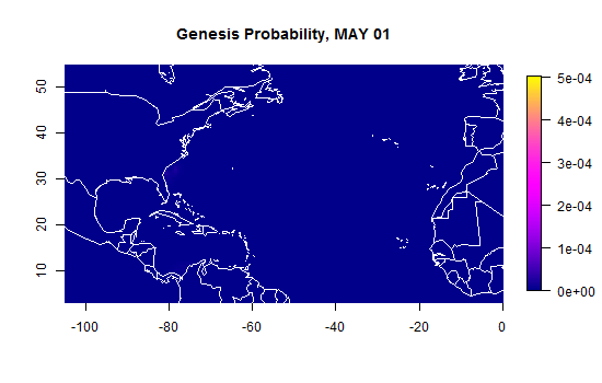
Fitting the second term of the model was challenging. Our commitment to the ½-degree spatial resolution and daily time step meant our model was defined on nearly 1 billion space-time grid cells over our 36-year calibration interval (1982-2017). Because the historical period contained only a few hundred cases of observed cyclogenesis events, our model setup required special fitting procedures tailored to the rarity of the “positive response” measured on such a fine space-time grid. The final product, shown in Figure 3, was worth it. The model produces hot spots of modeled TC genesis probability propagating across the basin together with the favorable environmental conditions.
The beauty of our two-term TC genesis model can be summarized as follows: The mean term ensures it produces the correct climatological behavior, while simulated TC genesis locations derived from these probabilities are physically consistent with the local and contemporaneous meteorology. Although we are currently driving our simulations with reanalysis data, climate change impacts on cyclogenesis, in theory, could be estimated by driving our model with output from climate models run under various climate change scenarios. Our framework also opens the door to simulations based on stochastically emulated environmental fields—another exciting area of active research at AIR we’ll leave for another blog post.
Editor’s note: The order of contribution to this piece was Suilou Huang, Michal Clavner and Suz Tolwinski-Ward. The corresponding author is Suilou Huang.


