


The North Atlantic hurricanes Harvey and Irma made landfall along the U.S. coastline within two weeks of each other, with Harvey arriving on August 25 and Irma on September 10, 2017. Moreover, as Category 4 storms they were both major (Saffir-Simpson Scale Category 3 or higher) hurricanes at landfall. We were curious to see how often major hurricanes made consecutive landfalls along the U.S. coast in the historical record.
Consecutive Hurricanes and Major Hurricanes
To investigate, we used the AIR historical catalog—based on the National Hurricane Center’s HURDAT2 dataset—as our data source. As it turned out, the chance of two hurricanes of any category landfalling on the coast within a 15-day (approximately two week) time window is not that small; it has, in fact, occurred a total of 17 times in 12 of the years in the post-1950 satellite era, which means that it sometimes occurred more than once within a single year (e.g., 2004). The chance of having a hit year (one with at least two hurricanes making U.S. landfalls within a 15-day window) is roughly 17 out of 100 based on the record of 1950–2017. [12/(2017-1950+1)=0.17]
The chance of getting consecutive major landfalling hurricanes is smaller but not trivial. In addition to 2017, it also happened in 1954 (Carol and Edna), 2004 (Frances and Ivan, Ivan and Jeanne), and 2008 (Gustav and Ike) based on the central pressure. So, the chance of the U.S. coast getting hit by consecutive major hurricanes in a single year is roughly 6 out of 100. However, all the storms mentioned above were Category 3 hurricanes—there were no consecutive landfalling Category 4 hurricanes post-1950 until Harvey and Irma in 2017.
Increasing Frequency with Climate Change?
We also investigated whether the frequency of consecutive landfalling hurricanes increases over time in response to a changing climate. We applied a sliding time window technique for the trend analysis; each year was classified as a hit (1) or nonhit (0) year, a sliding time window of 20 years was applied to the historical record, and the number of hit years was counted for the previous 20 years. For example, the value for Year 1969 is the total number of hit years from 1950 to 1969. The value for Year 1970 is the total number of hit years from 1951 to 1970, and so on. If we believe 20 years is long enough to represent a climate window, then sliding such a climate window along a time axis might show the climate change signal (if that signal is persistent) realized as an upward (or downward) trend.
We did the analysis first for all landfalling hurricanes and then for major landfalling hurricanes. We also varied the width of the sliding window using 20, 30, and 50 years. In addition, we varied the length of the included historical record to 1950 to 2017 and 1900 to 2017, respectively. The total number of hit years in sliding windows is plotted against time in Figure 1.
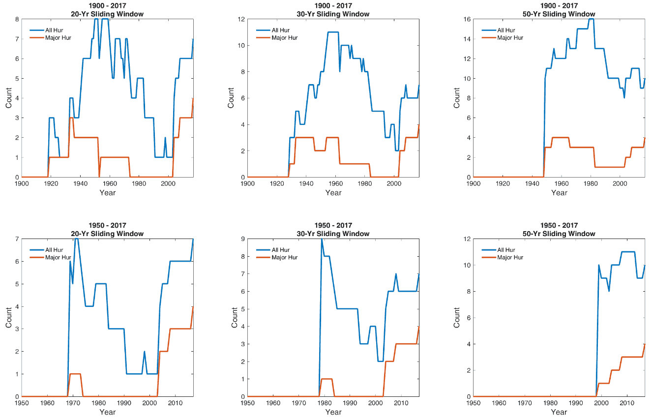
In the first analysis for all hurricanes, we could not see a clear trend regardless of either varying window widths or the record length (blue lines in Figure 1). The major-hurricane case is another story; a general upward trend is visible based on the 1950 to 2017 data (red lines in the lower half of plots in Figure 1). However, such an upward trend becomes much less certain if we increase the length of the historical record used (red lines in the upper half of plots in Figure 1).
To summarize, the strength of the belief in an upward trend in the occurrence frequency of consecutive major hurricanes greatly depends on the length of the historical record. This is due, among other factors, to the much greater amount of data available in the satellite era. If we only trust the 1950 to 2017 data, then the upward trend is clear; if we believe that the pre-satellite era data are trustworthy enough, then the trend is there, too, but it becomes much less certain.


