The coastal regions of Calabria and Sicily in southern Italy,over which Europe's most active volcano Mount Etna presides, are periodically affected by earthquakes-and, yes, even tsunamis. The area is located at the convergent plate boundary between the African and the Eurasian Plates, resulting in strong seismic and volcanic activity.
Almost a century ago, early on the morning of December 28, 1908, the region experienced a particularly devastating event. A severe submarine earthquake struck the Strait of Messina, the narrows separating Sicily from mainland Italy and connecting the Tyrrhenian Sea to the north with the Ionian Sea to the south. Its magnitude has been estimated at between 7.0 and 7.2 on the Richter scale.
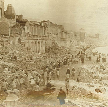
Damaged buildings facing the harbor of Messina, 1908 (Source: Library of Congress) |
The ground shaking lasted some 30 to 40 seconds and was widely felt throughout the Mediterranean region, as far as 400 km to the east and northeast in Albania, Montenegro, and the Ionian Islands of Greece. The earthquake generated a tsunami which caused considerable damage and loss of life within the Strait of Messina.
Soon after the event, more than 130 localities were surveyed to gather evidence relating to the tsunami, enabling the level reached by the waves, their period, and their direction of approach to be estimated. Measured along a 300-km-long segment of the eastern Sicilian coast, the mean run-up height of the waves was found to be about 5 m, although waves between 5 m and 12 m in height were noted on the 80 km coast between Galati Marina and Aci Trezza. An hour after the earthquake and about 250 km south of the epicenter, the tsunami was recorded in Malta, where the waves reached peak-to-peak amplitude of 90 cm with a period of about 20 minutes. Even after an intensive investigation in 2011/2012 the origin of the tsunami remains unknown, although new evidence suggests that it may have been triggered by the movement of the earthquake itself rather than a major landslide.
The earthquake and tsunami caused extensive structural damage over an area of more than 6,000 km², impacting the cities of Messina and Reggio Calabria on either side of the Messina Straits,as well as much of the surrounding coastal region. At least 60,000 casualties were reported, making this the deadliest natural catastrophe in recent European history. The early hour contributed to the death toll as many victims were still in bed rather than out in the comparatively safe streets and fields.
More than 90% of the buildings in Messina and Reggio Calabria were damaged or destroyed, the damage exacerbated by poor quality construction and building materials, including heavy roofs and vulnerable foundations. In addition, structures in the region had been weakened by significant earthquakes in 1894, 1905, and 1907.Communications and infrastructure in the affected area were severely disrupted and rescue operations, which were hampered by a series of aftershocks, had to rely on access from the sea.
Besides its devastating social and economic impact, the event was one of the first to be extensively investigated with modern instrumental data and field observations. Scientists and engineers from all over the world traveled to southern Italy immediately after the earthquake to examine the effects of ground shaking on buildings and on the natural environment. It also marked the beginning of building regulations in Italy to improve seismic resilience, with the first national standards introduced by Royal Decree in 1909.


