


Build It and They Will Come: The Role of Land Development in Natural Disasters
Jun 20, 2016
Editor's Note: For good or ill, humans change the world we live in—so much so that the term "Anthropocene" is used to describe the geological era in which our activities have increasingly defined the physical environment on Earth. In turn, however, the land development choices we have made are significant factors in determining how we fare against natural disasters.
Natural hazards are not inherently disastrous but become so when human systems fail to cope with their social, economic, and physical impacts. The root cause of any disaster is the underlying vulnerability and lack of resilience in those human systems when they intersect with a natural hazard.
Many land management activities influence the impact of natural hazards. Deforestation, for example, can increase the risk of landslides and aggravate flood risk by accelerating runoff and soil erosion. One of the land use choices that has the biggest impact on losses from natural disasters, however, is the rapid development up of our towns and cities, spurred on by our increasing desire to live in urban areas.
Urbanization
As well as growing, the world’s population is becoming increasingly urban. It is thought that by 2050, two-thirds of the people on the planet will be city dwellers. The world’s cities take up just 2% of the Earth’s surface, but as the World Economic Forum’s report Global Risks 2015 noted, “The concentration of people, assets, critical infrastructure and economic activities in cities exacerbates the potential of natural catastrophes to cause unprecedented damage.”
The amount of exposure at risk is increasing, the value of that exposure is growing, and concentrated urban development enhances the impact of many perils. It is obvious that should a tsunami, tornado, or hailstorm strike, it will damage more property in an urban setting than a rural one. The number and intensity of fires spawned by earthquakes can be exacerbated by dense urban development. The clearing of forests to accommodate new construction reduces surface friction and increases hurricane wind speeds.
 Jonathan Kinghorn
Senior Writer
Edited by Nan Ma
The article:
- The land use choices that communities make directly influence the severity of the natural disasters that impact them.
- The world’s cities form huge targets and are often in places that put them in harm’s way.
- Communities that understand the risks they face and have the ability to reduce and mitigate those risks become resilient and usually experience sustainable outcomes when impacted by natural hazards.
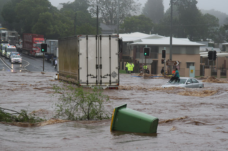
It isn’t just the structures being built that are a concern. Up to 90% of rain falling in a natural setting will infiltrate the ground, but an urbanized setting can cause as much as 90% to run off. The roads, parking lots, and other impermeable surfaces associated with development reduce the amount of natural drainage available and speed flood flows. According to the Federal Emergency Management Agency (FEMA), this may lead to a 10-year storm producing the runoff equivalent of a 25-year storm. The result is more runoff moving faster and increasing flooding downstream.
The December 2015 flooding in Chennai, India, illustrates how massive and rapid urban expansion—much of it ill-planned and some of it illegal—can compromise an area’s natural ability to absorb excess rainfall. When exceptionally heavy rainfall fell over an extended period, it quickly overwhelmed the area’s inadequate and poorly maintained drainage infrastructure and led to widespread major flooding and significant losses.
Old Settlements
People live almost everywhere, but many of our most successful settlements have been established in coastal areas and along rivers where fertile agricultural land, transportation, a water supply, and opportunities for trade are available. Many locations have been settled for hundreds—sometimes thousands—of years, and old development choices constrain the resilience of these communities today.
Many major settlements, particularly those around the Pacific Rim, are located on, or in close proximity to, active fault lines and have significant earthquake risk. Soft soils, which often accumulate in basins, along river banks, and in river deltas—prime locations for development—can amplify ground motion experienced by structures during a temblor. And in susceptible coastal and riverine locations, saturated soils can lose their strength in response to earthquake shaking, causing significant losses from liquefaction.

In addition to naturally deposited soils, areas reclaimed as a prelude to development can be at risk from liquefaction. In the U.S., Boston’s Back Bay area, recovered from salt marshes in the mid 19th century, is a prime example. Fortunately, infill like this compacts over time and becomes less vulnerable, as is the case with parts of Mumbai, India, reclaimed in the 18th century.
Flocking to the Coast
Coastal populations around the globe are growing faster than those in noncoastal areas; 15 of the world’s 20 megacities are in coastal zones. Globally, the average density of the near-coastal population (within 100 km of a shoreline and 100 m of sea level) is about three times higher than the global average. Population increase leads to property development. Within the U.S. the insured value of property in coastal states has historically doubled every decade, growing at an estimated compound annual rate of about 7%.
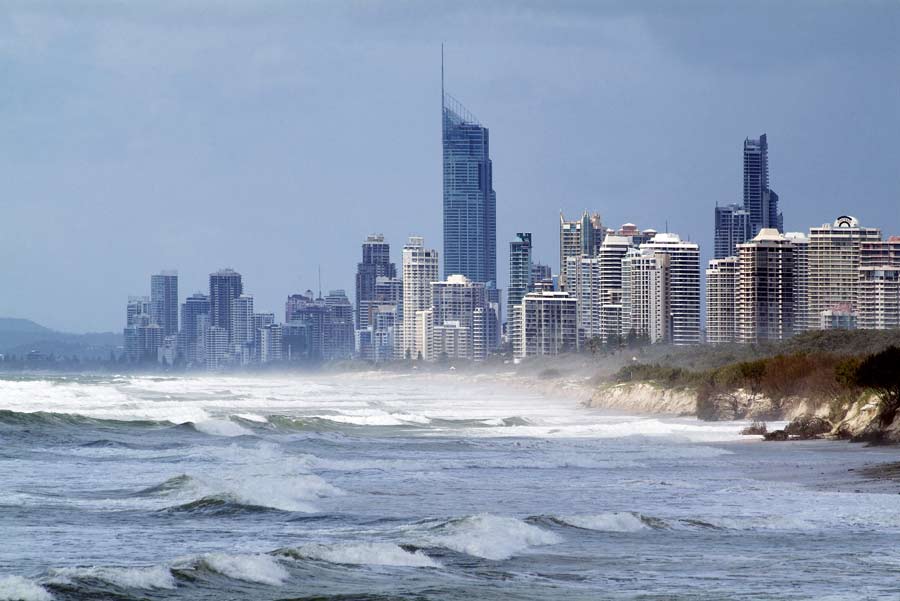
Proximity to water places many properties at risk. Coastal communities generally occupy low-lying locations with direct access to the sea, and this exposes them to damage from tsunamis and storm surges. The impact of these hazards is being magnified by rising sea levels, and in some locations by land subsidence. Low-lying areas along the southeast and Gulf coasts of the United States, the coasts of India and Bangladesh around the Bay of Bengal, and parts of Japan, the Philippines, and Indonesia are particularly vulnerable. In the UK, East Anglia and Kent are among the areas experiencing an increased risk of coastal flooding because of both land subsidence and rising seas.
In the United States, sea level rise and severe weather events are thought likely to increase the portion of coastal areas at risk of flooding by 55% this century, according to a report commissioned by FEMA. The floodplain along the Pacific Coast may increase by less than 50%, but for parts of the Gulf and Atlantic coasts, it is expected to more than double.
Major tsunamis are rare but devastating. Storm surge is more common and has been recognized as a major threat since the mid 19th century when Henry Piddington, the storm scientist who coined the term cyclone, accurately predicted that a new port being developed in India would be destroyed by one. Coastal development around the globe nevertheless continues unabated.
Inland Floodplains
Riverine floodplains are another area where development is growing. Almost one fifth of Hungary’s population lives on floodplains. Almost one in six properties in England, or about 5 million properties— 4 million of them residential—are located on floodplains having at least a 1-in-1,000 risk of floods. Land for construction is scarce, and floodplain development continues despite recent flooding. According to the Committee on Climate Change (independent advisors to the UK government), residential construction in low flood risk areas has risen 0.7%, but in high risk locations, it has grown 1.2% per year since 2011.
A recent report from the European Environment Agency states that more than 80% of Europe’s floodplains have been barricaded by flood defenses, drained, and built on, and it predicts a five-fold increase in flood damage by 2050. Of this additional damage, about one fifth will be attributable to the more intense rainfall anticipated, and the remainder to development on floodplains. It is important to note, however, that flood risk is not confined to floodplains, and that many areas away from them can be prone to flood damage and loss. In the U.S. for example, approximately 30% of National Flood Insurance Program (NFIP) insured losses occur off floodplains.
The Wildland-Urban Interface
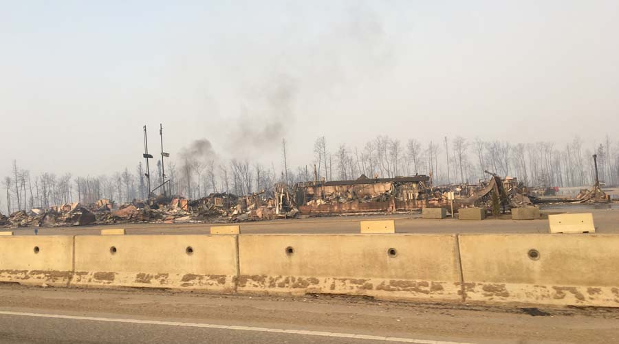
Not everyone wants to live in the center of a town or city. In the U.S. the number of homes in the wildland-urban interface (WUI)—where undeveloped forests, grasslands, and chaparral meet urban expansion—has increased significantly, particularly in the fire-prone western states. The massive May 2016 fire in Fort McMurray, Alberta, Canada, occurred largely in just such an environment. A recent study produced the first Europe-wide WUI map and identified the Catalonia region and the cities of Madrid and Valencia among locations most at risk there. Loss-causing wildfires result from a convergence of risk factors—increasing population and property in areas where there is a high accumulation of fuels and where it can be difficult to successfully prevent and suppress fires. Wildfire risk has also been exacerbated by beetle infestations, climate change–driven droughts, and ironically, by the practice of extinguishing wildfires as quickly as possible, which in some regions permits brush and trees to grow unabated and furnish additional fuel.
The data suggest an upward trend in U.S. wildfire losses during the last two decades, despite the fact that the frequency of wildfires has been relatively steady. This is a clear indication that, similar to other perils, the increase in insured losses from wildfires is driven primarily by an increase in the number and value of exposed properties in high-risk areas. The states most at risk are Colorado, Texas, and California. A similar situation exists in Australia, where as forested areas have become more developed, the urban and suburban property exposure is increasing in areas around Melbourne, Sydney, Adelaide, Hobart, and Perth.
Increased Resilience Is Key to Reducing the Impact of Natural Disasters
Communities that understand the risks they face and have the ability to mitigate those risks are far more resilient when impacted by natural hazards than those caught unprepared. When Chile, which has implemented robust safety measures such as effective building codes and public education programs, was struck by an M8.8 earthquake in 2010 some 525 people died; but a few weeks earlier when an M7.0 struck Haiti—which had implemented no such measures—223,000 were killed.
The adoption and effective implementation of appropriate building codes and public safety programs demonstrably do much to reduce the impact of natural catastrophes. Fortunately, there is also a growing awareness that good land use and planning also make essential contributions to their prevention and mitigation. It is encouraging, for example, that relocating people from areas most at risk from earthquakes is one of the goals being set by the Japanese government to reduce casualties in that country.
Around the world many communities are working hard to become more resilient, but 85% of people exposed to earthquakes, tropical cyclones, floods, and droughts live in developing countries where it can be particularly challenging to achieve good land use and planning. Continued property development is inevitable, and the value of the exposure at risk will rise. Only increased resilience—in the form of better awareness, mitigation, and the tools to measure and transfer the risk—can reduce the impact of natural disasters.
References
AECOM, Impact of Climate Change and Population Growth on the National Flood Insurance Program through 2100, June 2013
European Environment Agency, Floodplain management: reducing flood risks and restoring healthy ecosystems, 2016
FEMA, Managing Floodplain Development Through the National Flood Insurance Program, Unit 1. Floods and Floodplain Management
Sirio Modugnoa et al., “Mapping regional patterns of large forest fires in Wildland–Urban Interface areas in Europe,” Journal of Environmental Management, Volume 172, 1 May 2016
United Nations, Department of Economic and Social Affairs, Population Division (2014). World Urbanization Prospects: The 2014 Revision, Highlights (ST/ESA/SER.A/352)
World Bank, Cities and Climate Change: An Urgent Agenda, December 2010, Vol. 10
World Economic Forum, Global Risks 2015, 2015
