


Modeling Seismic Risk in South America: Five Years After the 2010 Maule Earthquake
Feb 19, 2015
Editor's Note: Since the powerful M8.8 Maule earthquake struck Chile in 2010, a wealth of new data and research on seismic risk in the region has become available. In this article, we discuss AIR's enhanced methodologies for modeling earthquake risk, which form the cornerstone of AIR's new and updated earthquake models for South America slated for release in summer 2015.
February 27, 2015, marks the fifth anniversary of the 2010 Maule earthquake, a powerful M8.8 event and the sixth largest ever recorded by a seismograph. The earthquake was triggered by a 500 km-long rupture within the Nazca subduction zone beneath central Chile. Two minutes of strong ground shaking ensued.
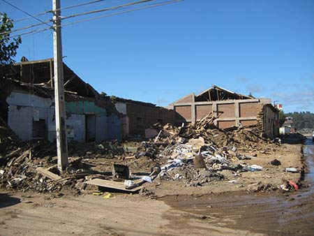
Thousands of adobe buildings crumbled, and even some engineered buildings adhering to modern construction practices did not escape damage. In all, more than 500,000 homes were damaged, and vital transportation, utilities, and telecommunications infrastructure were severely affected. In parts of Chile, the violent shaking caused loose, moist soils to temporarily lose their strength, resulting in cracking and uneven settlement of building foundations and roadways. The earthquake also triggered a tsunami that devastated hundreds of kilometers of the Chilean coastline. Taken together, the ground shaking and tsunami killed more than 500 people.
Since the Maule event, a wealth of data has become available that enables better and broader assessment of seismic risk in South America, including risk from tsunami and liquefaction. Using these new observations, along with novel hazard modeling techniques developed at AIR and a thorough reanalysis of regional vulnerability in each modeled country, AIR has completed an extensive update to our earthquake risk models for Chile, Colombia, Peru, and Venezuela. In addition, AIR has extended the model domain to include Ecuador, which benefits from these new data and upgraded modeling methodologies.
In this article, we present the highlights of the new AIR earthquake models for South America, which will be robust and valuable tools for the insurance industry.
New Approach to Modeling Seismic Hazard in South America
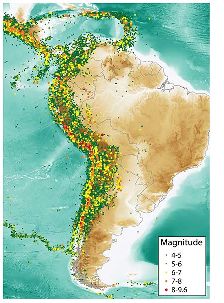
South America, particularly Chile, has a long history of earthquakes. In fact, the largest earthquake ever recorded—distinguished by its 9.5 magnitude—occurred near Chile's coast in 1960. Indeed, South America has been struck by 13 damaging earthquakes since 2007, including the powerful 2010 Maule and 2014 Iquique events.
 By: Dr. Claire Pontbriand
Scientist, Research & Modeling
 By: Dr. Mesut Turel
Engineer, Research & Modeling
 By: Dr. Molly J. Markey
Science/Technical Writer
Edited by Nan Ma, CCM
The article:
- New and updated AIR earthquake models for Chile, Colombia, Ecuador, Peru, and Venezuela (slated for release in summer 2015) were developed using the most up-to-date scientific data available.
- Models feature a novel approach to modeling time-dependent seismicity that addresses known shortcomings of published methods.
- By incorporating the results of peer review, the models' hazard and vulnerability components benefit from local experts' detailed knowledge, including that of building vulnerability to earthquake ground shaking.
Taking advantage of this rich historical record of earthquakes (see Figure 1), scientists can develop a time-dependent view of the region's seismicity that reflects the effects of recent earthquakes. However, with the standard approach—which typically models a single magnitude characteristic earthquake and recurrence time on a fault—it is difficult to capture the complexity of ruptures on the Nazca Trench.
Subduction zone earthquakes in the Nazca Trench are not generally characterized by a single large rupture that releases all accumulated stress within a fault segment. What typically occurs instead is a series of several smaller, sometimes overlapping ruptures, with each event discharging only some of the stress that has built up within the fault. Earthquakes can also change the local state of stress, influencing the probability of rupture on neighboring sections of the subduction interface. Therefore, the established method of modeling time dependency has limitations for the South America region.
To account for these complexities, AIR scientists have developed a novel approach for modeling time-dependent seismicity. By acknowledging the effects of ruptures in the Nazca subduction zone, and by considering the buildup and transfer of stress over time, the new AIR time-dependent seismicity model is a step advance over other earthquake hazard models for the region.
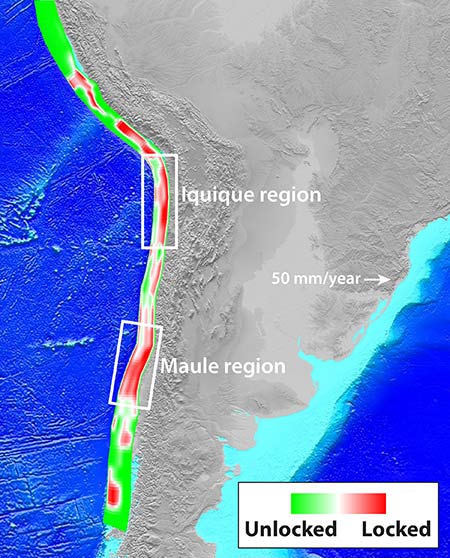
AIR's new approach to modeling earthquake hazard for South America also benefits from kinematic block models—models that employ GPS data to estimate how tectonic plates move and deform—that were developed in-house by AIR scientists.
By quantifying strain accumulation at nearby plate boundaries using 20 years of GPS data, kinematic block models reveal "locked" fault segments that could rupture in the future. For example, the AIR block model results suggest a complex, alternating pattern of locked and unlocked regions of the Nazca subduction zone and capture the high accumulations of strain in fault segments in the regions of the 2010 Maule and 2014 Iquique earthquakes (see Figure 2). The AIR time-dependent model reflects the stress release and impact of these recent ruptures.
Together with a revised view of time-dependent seismicity in the region, kinematic modeling is helping AIR scientists discern which regions of South America are most susceptible to damaging earthquakes in the future.
Region-Specific Assessment of Earthquake Vulnerability
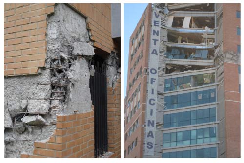
Recognizing the region's high seismicity, the government of Chile has instituted some of the strictest and most rigorously enforced building codes in the world. For 10 years after a new building is constructed, Chilean law holds the building's original owner liable for damage and losses that can be traced to code violations—even if the building has changed ownership. Construction plans for public buildings such as schools and hospitals, and for apartments/condominiums over five stories high must be approved by an independent reviewer. These measures played a major role in preventing even worse property damage (see Figure 3) and loss of life from the 2010 Maule earthquake.
Other countries in the region have taken similar steps to reduce their vulnerability to earthquakes. In Peru, stringent design requirements that have been in place since 1997 are credited with preventing damage to schools and other public buildings from large earthquakes, such as the M8.4 Atico earthquake in 2001. In Colombia, recent building codes mandate thorough inspections during construction to ensure code compliance, although no independent review of the proposed building plan is required.
These examples highlight a complicating factor in quantifying building vulnerability: The specifics of building codes—and the details of how they are implemented and enforced—can vary significantly among countries (and even regionally within countries). This is particularly true for housing, which is not as heavily scrutinized as commercial projects. Construction practices also vary among the modeled countries. A four-story reinforced concrete apartment building in one country, for example, could be much more resistant to earthquakes than one in a different country—even if both buildings were intended to withstand the same level of ground shaking.
To ensure that the South America earthquake models accurately estimate the damage and loss that can result from a seismic event, AIR engineers accounted for these regional differences during model development. While published studies are an important source of building code information, critical details—such as how closely actual construction practices adhere to code requirements—may not be available in the literature. Therefore, AIR engineers consulted with local researchers to obtain a vital "on the ground" viewpoint of building vulnerability, and combined these insights with available published data. The result is a regional assessment of building vulnerability, including how these vulnerabilities have changed over time, that forms the cornerstone of the updated AIR models' damage estimation procedure.
Ground Shaking Is Not the Only Threat
The risk of earthquake-triggered tsunamis and liquefaction has also been reassessed in light of the 2010 Maule earthquake. During most earthquakes, ground shaking is responsible for the majority of property damage. But the tsunami triggered by the Maule earthquake devastated many coastal communities in Chile, producing wave heights of up to 17.2 meters in some locations.
Much of the town of Constitución, which had been a popular tourist destination, was heavily damaged by the tsunami. While buildings in the hills were generally unscathed, those parts of the town on the plain were devastated. The town of Dichato was also hard hit, with more than 75% of its buildings destroyed by the tsunami waves that covered the town with 7.6-10.5 meters of water. Geological data show that other damaging tsunamis have struck South America's Pacific coastline during past large earthquakes.
In addition to triggering a major tsunami, the Maule earthquake also destabilized, or liquefied, loose moist soils—such as those along riverbanks—causing them to lose strength and stiffness. This led to cracked and tilted roads, building foundations, and bridges. Liquefaction from the Maule earthquake badly damaged several bridges spanning the Bio-Bio River, and also tilted railroad beds near Concepción, rendering them unusable.
Future earthquakes in South America have the potential to trigger tsunamis and liquefaction and cause even worse damage to buildings and infrastructure than ground shaking alone. Acknowledging the significant impact these associated perils can have on insured properties in the region, the AIR earthquake models for South America calculate losses caused by earthquake ground shaking, tsunami, and liquefaction.
Own Your Risk
Five years ago, the Maule earthquake was a stark reminder of the catastrophic damage that the shifting earth can cause in South America. However, it is important to note that stronger—and much more costly—earthquakes are possible. If an event like the 1960 Valparaiso M9.5 earthquake in southern Chile were to happen today, AIR estimates that it would cause more than USD 10 billion in insured losses.
Catastrophe models help insurance companies to more fully own their risk by preparing for the impact of low frequency, high severity events—even ones that have no precedent in the historical record. Models enable not only the estimation of potential losses but also inform exposure accumulation management, actuarially sound ratemaking, portfolio management, and reinsurance purchasing.
By capturing a comprehensive view of South America's complex seismicity and vulnerability, and covering earthquake-triggered perils such as tsunami and liquefaction in addition to ground shaking, AIR's new earthquake models for Chile, Colombia, Ecuador, Peru, and Venezuela give companies a distinct advantage in preparing for the next great South American earthquake.
