


Which Wind Speed?
May 27, 2014
Editor's Note: In the days and hours leading up to the landfall of Super Typhoon Haiyan there was considerable confusion regarding the storm's strength. Much of that confusion came from the different wind speed estimates being issued by meteorological agencies and reported in the press. In this article, Jason Butke, Principal Scientist at AIR Worldwide, explores how two meteorological agencies in the Northwest Pacific basin estimate tropical cyclone intensity and sheds light on why their estimates do not always agree.
Introduction
On November 7, 2013, Super Typhoon Haiyan made landfall in the Philippines. The storm and its accompanying surge leveled buildings and killed more than 6,000 people, becoming one of the deadliest typhoons to ever hit the island nation. The storm was exceptionally powerful; every meteorological agency agreed on that much. Exactly how powerful? Well, they couldn't agree.
In the hours leading up to Haiyan's landfall, the Japan Meteorological Agency (JMA) reported maximum sustained wind speeds at 231 km/h (144 mph). At about the same time, the Joint Typhoon Warning Center (JTWC) reported maximum sustained wind speeds of 315 km/h (196 mph). Given that the relationship between wind speed and damage (whether from wind or storm surge) is not linear, this difference has important, even deadly, implications as meteorological agencies issue warnings to those at risk.
Different Dvorak Techniques
Because meteorological organizations typically do not send hurricane hunter aircraft to monitor tropical cyclones in the Pacific—and few ground instruments survive intense storms—there can be considerable uncertainty in tropical cyclone wind speed estimates. Rather than being measured directly, they are estimated using the Dvorak technique, which relates a satellite image of a tropical cyclone to a maximum sustained wind speed. (For a detailed explanation of the Dvorak technique, and other measurements and estimates of cyclone intensity, please read "Best Track Data," and "The Pressure's On").
 By: Jason Butke
Principal Scientist
Edited by Eric Bland
The article: Discusses the differences between the wind speed estimates for tropical cyclones in the Northwest Pacific basin from the JMA and the JTWC.
Highlights: To estimate tropical cyclone intensity from satellite imagery, the JMA developed their technique based on storms that affected Japan, while JTWC based theirs on storms that have occurred across the entire Northwest Pacific basin. These small differences can have a big impact on wind speed estimates.
The Dvorak technique is somewhat subjective, as it relies on an observer's interpretation of the storm image.1 For Haiyan, this wasn't an issue; both the JTWC and the JMA assigned it a Current Intensity (CI number) of 8, the highest value possible. Each agency then consults a table that relates the CI number to a maximum sustained wind speed. The tables used by each agency, however, were developed using different base information. JMA developed their technique based on storms that have affected Japan, whereas JTWC developed their technique based on storms that have occurred across the entire Northwest Pacific basin. Using the JTWC's table, a CI number of 8 corresponds to a maximum sustained wind speed of ~315 km/h (196 mph). On JMA's table, an 8 corresponds to a maximum sustained wind speed of ~226 km/h (140 mph).
This brings us to another difference between the agencies. Winds are inherently gusty; when agencies measure or estimate wind speeds, they report them as an average over different averaging times. The JMA, along with most meteorological agencies around the world, uses a 10-minute averaging time, while the JTWC uses a 1-minute averaging time. Ten-minute wind speeds are slower than 1-minute wind speeds, usually by a factor of 1.10–1.20 for tropical cyclones. To convert the JMA's 10-minute wind speeds to 1-minute wind speeds to make a more meaningful comparison, a conversion factor of 1.14 was used.
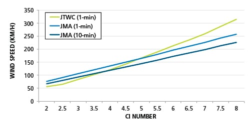
Even with the conversion, Figure 1 shows that there is a significant difference in wind speeds assigned by the agencies at a CI number of 8—a difference of nearly 60 km/h. And as the graph shows, the JTWC estimates lower wind speeds than the JMA for weaker typhoons and estimates higher wind speeds than the JMA for more powerful typhoons.
Official or Unofficial
The World Meteorological Organization (WMO) has tasked Regional Specialized Meteorological Centers (RMSCs) with minimizing the loss of life and damage caused by tropical cyclones by providing track and intensity forecasts in real-time. The WMO divides regions of TC formation into seven basins, monitored by six RSMCs and six regional Tropical Cyclone Warning Centers (TCWCs), which have similar responsibilities (refer to Best Track Data for more information). The JMA is the official agency in the Northwest Pacific basin. When available, AIR uses track and intensity information from the JMA for real-time loss estimates and for regional model development.
There are at least six "unofficial" government agencies that provide their own tropical cyclone tracks and meteorological information, including the JTWC. The JTWC is a U.S. government entity run by the U.S. Department of Defense; it is not sanctioned by the WMO. The JTWC products provide support to all military branches of the U.S. government as well as other government agencies, including the U.S. National Weather Service. JTWC products "are intended for use by U.S. government agencies." Anyone looking for more localized information on the JTWC's website is encouraged to use the national meteorological agency or the appropriate RSMC for tropical cyclone products pertinent to that country, region, and/or local area.2
Interestingly, U.S. media outlets heavily rely on the JTWC when discussing tropical cyclones, perhaps simply because it is a U.S. agency. Another possibility is that they use JTWC estimates because the wind speeds are almost always higher (1-minute averaging time) compared to JMA estimates (10-minute averaging time), making for a better news story.
Closing Thoughts
As Typhoon Haiyan demonstrated, estimates of typhoon intensity by different agencies can vary significantly, and direct observations—even when available—are rarely able to capture the true maximum wind speed of a storm. Because of the many difficulties associated with obtaining maximum wind speeds, AIR uses central pressure instead as the principal measure of tropical cyclone intensity when modeling storms. Central pressure is both easier to measure and prone to fewer (and smaller) errors. As mentioned previously, AIR uses JMA data when available, and unlike the JTWC, the JMA provides central pressure measurements for storms in real-time and as part of their database of historical typhoons. (The JTWC began providing both central pressure and wind speed in 2001.)
Researchers continue to study Haiyan from various perspectives, and it remains to be seen whether one agency's estimate or the other's will ultimately be deemed the more accurate. Knowing what's behind the estimate from each agency will enable risk managers to better understand the uncertainty behind a storm's reported intensity and provide some much needed perspective the next time a Pacific typhoon approaches landfall.
1 An advanced objective Dvorak technique is used by some research and academic institutions. JMA is evaluating an objective Dvorak analysis that may go operational in the future.
2 http://jtwccdn.appspot.com/JTWC/products-and-services-notice
Barcikowska, M., Feser, F., and Storch, H. von. (2012). "Usability of Best Track Data in Climate Statistics in the Western North Pacific." Monthly Weather Review, 140, 2818-2830.
Butke, J. (2013). "Best Track Data." AIR Currents, January 2013. Available online: "/Publications/AIR-Currents/2013/Best-Track-Data/
Sousounis, P. (2008). "Changing the way we measure hurricane intensity." AIR Currents, Feb 2008. Available online: https://www.air-worldwide.com/_public/NewsData/001409/AIRCurrents_HurricaneIntensity.pdf
