


Iselle: A Myth-Busting Hawaiian Tropical Cyclone
Sep 24, 2014
Editor's Note: Think only the westernmost Hawaiian islands are at risk from tropical cyclones? Think again. To learn more about the AIR Tropical Cyclone Model for Hawaii, please read the AIR Currents article: "The 20th Anniversary of Hurricane Iniki: Assessing Tropical Cyclone Risk in Hawaii"
On August 8, 2014, Tropical Storm Iselle made landfall on the Big Island of Hawaii's Kau Coast. It was the first tropical cyclone landfall on the Big Island since an unnamed storm arrived on its shores in 1958. Iselle had sustained winds of 60 mph at landfall, but less than a day before landfall, the storm was still at hurricane strength. A subsequent AIR damage survey of the impacted areas revealed some property damage and numerous downed trees.
In this article, we'll address two common myths about storms in Hawaii: One, they only hit the island of Kauai, and two, the Big Island's tall volcanoes destroy any storms that do pass, effectively protecting the other islands to the west.
Myth 1: Tropical Cyclones Only Hit Kauai
The two most recent hurricanes to impact the state of Hawaii both hit the island of Kauai, the westernmost of Hawaii's main islands. Hurricane Iwa bypassed the island in November 1982, and in September 1992—just weeks after Hurricane Andrew hit Florida—Hurricane Iniki struck Kauai as a Category 4 storm, causing extensive damage across the island. Because the Hawaiian Islands are small targets in the Pacific and landfalls here are rare, these two storms are largely responsible for the long-held belief—the misconception—that Kauai is the only island at risk from tropical cyclones.
The strongest hurricanes tend to approach Hawaii from the south, given the profile of sea surface temperatures in the vicinity of the islands; however, all the islands are at risk from storms approaching from that direction. In fact, the AIR Tropical Cyclone Model for Hawaii assumes equal risk across the islands, a finding that was supported by two professors from the University of Hawaii who peer reviewed the model.
Further evidence that Kauai is not the only island at risk is presented below.
 By: Scott Stransky
Principal Scientist
 By: Kyle Butler, Ph.D.
Senior Engineer
Edited by Sara Gambrill
Article Highlights:
- Steering currents in the Central Pacific basin can direct storms to any of the Hawaiian Islands, not just Kauai.
- Examining accounts that predate the official historical record gives a fuller picture of the risk.
- The two volcanoes on the Big Island do not protect the other Hawaiian islands from tropical cyclones arriving from the east.
Steering Currents
AIR has analyzed steering currents from 1948–2010 in the North American Regional Reanalysis (NARR) data set. Steering currents give us an idea of where storms were likely to have moved at any given time and are especially important for understanding tropical cyclone risk in the Central Pacific basin because of the low frequency of events that impact Hawaii.
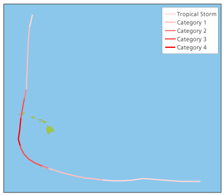
If we look at Iniki's movement (Figure 1), for example, we can see that the hurricane was well south of Hawaii and moving westward when it made a sharp right turn to directly hit Kauai. The steering current data indicate that sharp right turns in the flow—while not very common—do happen, but don't necessarily always steer storms to Kauai. Oahu, Maui, or even the Big Island, are all equally viable targets.
Historical Evidence
The official historical database of Central Pacific tropical cyclones maintained by the National Hurricane Center begins in 1949. Sixty-five years is not a long record, especially for Hawaii, which is not impacted by hurricanes often. To supplement this short “official” record, we collected information on earlier tropical cyclones by studying newspaper records and anecdotal evidence.
One key event was an 1871 storm that was dubbed "the Kohala Cyclone." While we do not have a track, footprint, or parameters for this event, we do have useful information from eyewitness reporters at the Hawaiian Gazette. The article notes that the center of the storm was in the vicinity of Maui, which is east of Oahu and Kauai.
Myth 2: The Big Island's Volcanoes Break Up Storms
Many people believe that Mauna Loa and Mauna Kea, two nearly 14,000-foot volcanoes on the Big Island, would completely destroy any tropical system that passes overhead. Iselle demonstrated, by way of both meteorological data and damage survey data, that this is not the case.
Meteorological Data
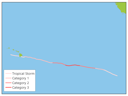
While Iselle's circulation was disrupted by its passage over Mauna Loa and Mauna Kea, the Central Pacific Hurricane Center (CPHC) continued tracking the storm afterward, which means that the volcanoes had not completely destroyed the storm.
In fact, although interaction with the island and volcanoes played a role in weakening Iselle, increased wind shear as the storm neared landfall (28 to 35 mph from the northwest) probably contributed just as much to the storm's weakening. Still, Iselle emerged over the ocean on the west side of the island as a 50 mph tropical storm (see Figure 2).
AIR Damage Survey
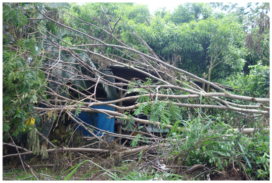
The damage observed from Iselle was in line with expectations for a storm of its size and intensity. Direct wind damage was largely confined to roofs, including lost shingles and damage to older or poorly attached metal roofing. Failure of the roof (i.e., loss of cover and decking) was observed mainly on the older, single-wall construction homes. These homes lack good connections and continual load paths to help resist even low-level winds. In some cases, the terrain itself may have channeled the winds to a particular area, increasing the wind speeds beyond that which the older roofing systems could withstand.
Much of the damage to both homes and infrastructure, however, was not a direct result of the wind. Rather, it was caused by wind damage to the numerous albizia trees on the Big Island. Albizia trees were introduced to the Hawaiian Islands from Indonesia around 1920 to provide shade. They grow quickly, up to an inch a day with maximum heights of around 150 feet, and have a broad canopy that can be large enough to shade half an acre.
However, their massive limbs are connected to a relatively small trunk, and the brittle wood and weak structure are supported by shallow roots, posing a significant hazard to structures in high wind from uprooting or breakage. Estimates from the Iselle cleanup suggest that 90% of the damage caused by trees was likely attributable to albizia trees.
Read more about AIR's damage survey in this In Focus blog post.
Iselle's Impact on Our Understanding of Hawaii Hurricanes
Although Iselle was not a particularly damaging storm, it provided a relatively rare opportunity to observe up close the impact of high winds on Hawaii. Furthermore, it confirmed what AIR and other leading researchers already knew about Hawaii tropical cyclone risk: not only are all the islands at risk from tropical systems, but the Big Island's large volcanoes may not protect the other islands from westward moving storms. Ultimately, Iselle not only busted a couple of long-standing myths, but also reinforced the fundamental fact that, while not impacted often, Hawaii is indeed at risk from tropical cyclones.
