


Northeast Hurricanes—And Recalling The Great New England Hurricane of 1938
Sep 19, 2013
Editor's Note: This month marks the 75th anniversary of "The Great New England Hurricane of 1938," the most destructive hurricane to strike the U.S. Northeast in the 20th century. In this article, Tim Doggett and Robert Zalisk describe the 1938 hurricane and its impact, compare it to 2012's Sandy, and explore how frequently Northeast hurricanes may be expected in the future.
Seventy-five years ago on September 21, "The Great New England Hurricane of 1938" devastated large areas of the northeastern United States. Last year's Hurricane Sandy provided a more immediate reminder that the devastation hurricanes can cause is not limited to the southern coastal states. While other damaging storms have also struck the Northeast during the years that separate these two storms, the relatively low frequency of these high impact events complicates the effort to quantify the risk associated with them.
HURDAT
The National Hurricane Center (NHC) documents historical Atlantic basin hurricane events going back to 1851 in its official data set known as "HURDAT" (short for HURricane DATabase). The database contains intensity and track information, providing a means for quantifying the frequency and severity of storms that have impacted the U.S.
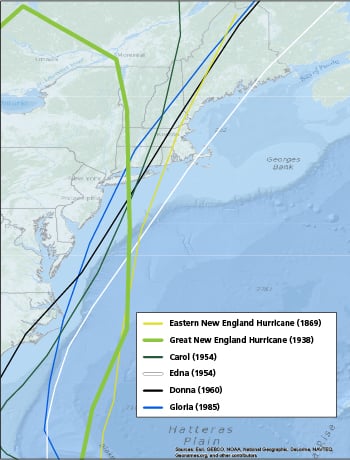
HURDAT shows that only six major hurricanes (Category 3 or higher on the Saffir-Simpson Hurricane Wind Scale) have made landfall from New Jersey northward between 1851 and 2012: the Eastern New England hurricane of 1869, the 1938 Great New England hurricane, and Hurricanes Carol (1954), Edna (1954), Donna (1960), and Gloria (1985)—all shown in Figure 1.
 By: Tim Doggett, Ph.D.
Senior Principal Scientist, Research
 By: Robert Zalisk
Senior Science Writer
Edited by Nan Ma
The article: This article compares the 1938 hurricane and 2012's Hurricane Sandy, describes the frequency of major landfalling hurricanes in the U.S. Northeast since 1851, and efforts to augment the official historical record.
Highlights: Researchers are using forensic techniques to discover and characterize ancient events. Consistent with HURDAT, the results indicate that the Northeast experiences at least two to three catastrophic hurricane events per century.
The 1938 Hurricane: The Most Powerful in the 20th Century
The most significant and destructive of the major Northeast hurricane events of the past 100 years was the Great New England Hurricane of 1938 (sometimes called "The Long Island Express"). The storm developed near the Cape Verde Islands and is thought to have reached Category 5 strength east of the Bahamas.
The hurricane's maximum sustained winds at the time of landfall are estimated to have been 120-125 mph (a strong Category 3), and landfall occurred during an astronomical high tide, greatly enhancing the impact of its storm surge. Sustained hurricane force winds (in excess of 74 mph) occurred throughout much of southern New England, while winds in excess of 90-100 mph were reported throughout Connecticut and Rhode Island. The hurricane also produced storm tides of 14 to 18 feet across most of the Connecticut coast, with 18- to 25-foot tides reported from New London east to Cape Cod. The eye of the hurricane was observed as far north as southern Vermont.
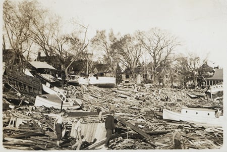
New England suffered extensive damage to buildings, infrastructure, crops, and trees. Power outages were widespread and in some areas lasted for weeks. Significant damage was inflicted from New Jersey to Vermont, with an estimated 57,000 buildings damaged or destroyed. AIR estimates that if the hurricane were to happen today, insured losses would amount to about USD 33.3 billion.
2012's Hurricane Sandy—Compared with 1938
Last year's Hurricane Sandy provided the Northeast with a costly wake-up call to the substantial risk it faces from hurricanes. Although Sandy and the 1938 hurricane made landfall in different locations, there were some areas of overlap between the two storms, especially in northern New Jersey and New York.
Both storms had extensive wind fields, with damaging winds observed many hundreds of miles away from the storm center. Whereas storms that travel north usually eventually veer toward the east, back out to the mid-ocean, both the 1938 storm and Sandy had their paths diverted westward by high pressure systems, and both storms were in the process of making an extratropical transition when they made landfall. Most notably, both storms occurred during periods of astronomical high tide, contributing to the extraordinarily high storm surge both exhibited.
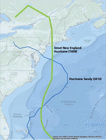
While Sandy caused severe storm surge damage in many locations, it was less intense than the 1938 hurricane with respect to sustained maximum wind speeds. In fact, sustained winds were well below the Category 3 level winds recorded in 1938. Similarly, many of the Northeast locations most strongly impacted by storm surge in 1938 were spared by Sandy. Nonetheless, Sandy's insured losses currently exceed USD 18 billion, according to the latest PCS® reports.
Estimating Storm Frequency
To responsibly prepare for the next big Northeast storm—public officials, emergency responders, and risk managers need to know how often such events happen. The occurrence of six major hurricane events in 162 years might indicate a mean recurrence interval of approximately 27 years. Data quality, however, varies across the time period covered by HURDAT. For example, recent review of wind and damage reports for Hurricane Donna and Hurricane Gloria (both currently listed as major hurricanes) suggests that in a future reanalysis of HURDAT events, they could be reclassified as Category 2 storms. Were that to happen, the mean recurrence interval for major Northeast hurricanes would jump to about 40 years—an increase of nearly 50%.
The small sample size of Northeast storms makes it challenging to formulate a robust estimate of their frequency—which in turn is central to estimating the risk associated with them. Researchers are thus looking outside the current official HURDAT record to better understand the risk.
Additional Historical Accounts
There are in fact historical accounts of large storms impacting the Northeast prior to the time period covered by HURDAT. But because of the subjective nature of narrative storm reports (that include few, if any, modern metrics), counts of hurricanes before 1851 are not reliable. That said, it is likely that the strongest storms—major hurricanes—were those most likely to have been reported, given their widespread impact. Among the storms whose characteristics and intensity have yet to be officially estimated are two described in an NHC study, the "Great Colonial Hurricane of 1635" and the "Great September Gale of 1815." Another, the "1821 Norfolk and Long Island Hurricane," is described as having caused catastrophic damage in New York and Long Island; it was accompanied by a storm surge of 13 feet and may have been one of the worst storms to impact New York City in more than 200 years.
Using Forensic Evidence to Enrich the Record
One of the difficulties in using historical narratives is quantifying the intensity of the storms they describe in an objective manner. This problem is being addressed by studying soil profiles at coastal locations. Over time, soil builds up in layers and records an environmental history in much the same way as trees produce growth rings. A cross section of coastal soil displays layers of sand mixed in with the many layers of soil. They are the residue of events in which large amounts of sand washed over the land, and thus are associated with major storm surge occurrences. Estimates of the age of the sand layers can be obtained through chemical analysis and by benchmarking to known historical events.
Studies using this technique are beginning to expand the understanding of historical storm occurrence in the Northeast. One study demonstrated that two events from the 1630s had storm surges that exceeded that of the 1938 hurricane. Using radiocarbon dating, the probable occurrence of two other extreme events was established, one likely between 1295 and 1407, and the other between 1404 and 1446. In a study of Rhode Island locations, it was found that in the past 700 years, at least seven intense hurricanes had struck the southern Rhode Island coast.
Similar studies done in Boston, Long Island, and New Jersey found that the frequency of intense events was lower for New Jersey than for the other sites. Prior to Hurricane Sandy, the 1821 hurricane mentioned earlier was the only intense hurricane known to have made landfall in New Jersey in the past 350 years. However, these studies found evidence of a major event between 1278 and 1438 whose impact would have been far worse than that of any other storm seen to date.
These investigations, by their very nature, focus on the recurrence of events at specific locations, and thus underrepresent the overall regional frequency. More forensic investigations will help to establish the geographic extent and intensity of those storms that have not otherwise been recorded. However, with such research already helping to augment the established historical record, it appears that the Northeast experiences at least two to three catastrophic hurricanes per century, a frequency consistent with the HURDAT record.
Waiting on the Next "Big One"
The northeast United States has not been visited by another hurricane as strong as the "Great Hurricane" of 1938 for 75 years. Yet the region is very susceptible to a major hurricane catastrophe. It is important to remember that for all the extensive storm surge damage caused by Hurricane Sandy, the hurricane of 1938 was a more powerful storm—and history demonstrates that storms even more powerful have occurred in the more distant past.
Many areas in the Northeast have experienced significant exposure growth and have not had their defenses tested in decades. Today, the insured value of commercial and residential properties in just the Northeast coastal counties is USD 5.3 trillion. Hurricane Sandy perhaps provides a window on how the region will fare when the next "Big One" occurs. While the insurance industry has been able to absorb the blow of Sandy's multibillion dollar price tag, the damage and dislocations Sandy inflicted and the resulting claims settlement and flood coverage issues reveal that the Northeast needs to be better prepared.
It is only a matter of time—quite possibly a short time—before another major hurricane ventures northward and impacts the region with the full force of "The Great New England Hurricane of 1938."
Bossak, B. and Elsner, J. (2003). "Use of GIS in Plotting Early 19th Century Hurricane Information" Historical Hurricane Information Tool, FSU.
Donnelly, J.P., et al. (2001). "A 700-year sedimentary record of intense hurricane landfalls in southern New England". GSA Bull. 113, 714-727.
Donnelly, J.P., et al. (2001). "Sedimentary evidence of intense hurricane strikes from New Jersey". Geology 29, 615-618.
Jarvinen, B., (2006). "Storm tides in Twelve Tropical Cyclones (including four intense New England Hurricanes". National Hurricane Center.
