


Insights into Damage and Vulnerability from AIR’s Moore Tornado Survey Team
Jun 27, 2013
Editor's Note: AIR dispatched a team to survey damage in Moore, Oklahoma, caused by the Newcastle/Moore-South Oklahoma City (OKC) tornado five days after it struck. Team members included Dr. Agerneh Dagnew, Engineer, and Scott Stransky, Senior Scientist. In this article, Stransky and Dagnew discuss the survey findings and how they inform AIR's understanding of severe thunderstorm risk.
About five miles south of Newcastle, Oklahoma, at 2:56 p.m. on Monday, May 20, 2013, a powerful tornado touched down and tracked northeastward for nearly 17 miles. It took about 50 minutes to do so. At 3:01 p.m., the tornado—now at EF-5 intensity—struck Moore, a suburb of Oklahoma City, killing 24 people and destroying more than 1,000 homes, businesses, and public buildings.
The meteorological conditions that produced the Moore tornado were a slow-moving, upper-level low pressure system that triggered a severe thunderstorm outbreak across the Central Plains on May 19, coupled with very warm, humid air moving northward from the Gulf of Mexico ahead of a surface cold front, and wind shear associated with an approaching increase in jet stream energy. All together these factors produced highly unstable atmospheric conditions that caused the storms on the afternoon of May 20 to rapidly evolve into tornadic supercell thunderstorms.
The tornadoes spawned by these supercells were long-lived due to the orientation of the track and the severity of the conditions. In all, the system produced 22 tornadoes on May 20, 2013. Most occurred in Oklahoma, but tornadoes were also reported in Missouri, Texas, Kansas, Arkansas, and Colorado. The Moore tornado was by far the most damaging. Property Claims Services has published an initial insured loss estimate of USD 1.575 billion for the entire outbreak, of which USD 1.15 billion is for Oklahoma alone.
What follows is a detailed look into the type of damage caused by the Moore tornado and the vulnerability of engineered and non-engineered structures of different construction to violent tornadic winds.
 By: Dr. Agerneh Dagnew
Engineer, Research
 By: Scott Stransky
Senior Scientist, Research
Edited by Sara Gambrill
The article: Describes the type of damage caused by the May 20, 2013, Moore tornado and the vulnerability of engineered and non-engineered structures of different construction to violent tornadic winds.
Highlights: Insights into the wind speed cross-section of an EF-5 tornado, damage characteristics for various occupancy and construction types, and damage mechanisms of tornado wind—borne debris and how far it can travel.
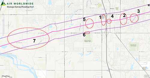
Identifying Survey Sites
With information from the National Weather Service (NWS), the Federal Emergency Management Agency (FEMA), and the U.S. Geological Survey (USGS), AIR identified areas along the tornado's track where EF-4 and EF-5 winds were reported or where commercial and residential exposures were concentrated (Figure 1). With these designated areas of interest loaded onto handheld GPS devices, the team set out.
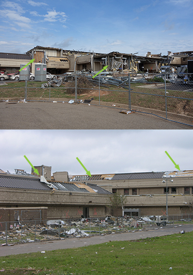
Commercial Properties near I-35, Exit 117 (Site 1)
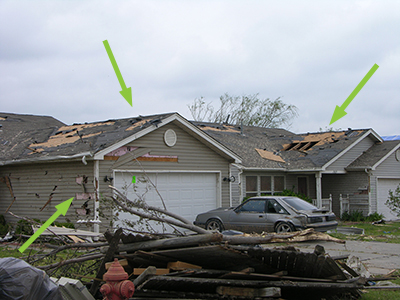
Site 1 was where several commercial properties, such as the medical center, bowling alley, and movie theater, were located. These buildings appeared to be well-engineered commercial establishments. Still, the tornado caused severe damage to the medical center and bowling alley. The extensive cladding and roof damage, failure of some structural elements, collapse of the parapets, loss of rooftop equipment, and broken windows and doors of the medical center revealed that it had been in the tornado's core (see Figure 2). The movie theater and the post office just a few hundred feet away, however, only sustained minor damage to siding and roof flashing.
Residential Areas East of I-35 (Sites 2, 3, and 4)
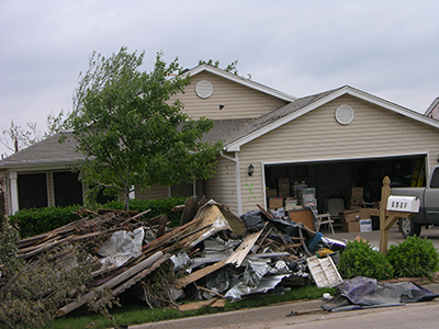
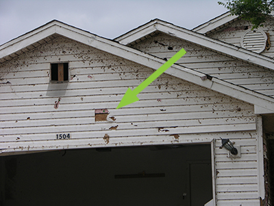
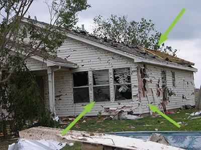
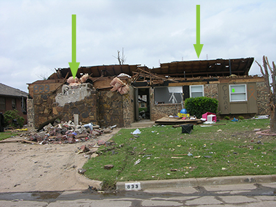
The team then surveyed three residential areas to the east of I-35, each time heading out perpendicular to the tornado's path to assess the level of damage in the tornado's cross section. The first area was near Silver Leaf and 8th, the next area was on Whispering Oaks Boulevard, and the third was on Howard and Broadway. The majority of the exposures in these areas were single-family wood frame and brick buildings. The tornado's width spanned several blocks, within which a one-block wide area of leveled homes was typically observed near the center, flanked on both sides by one block of structures that were nearly leveled but had parts of their walls still standing, and beyond that several blocks of minor to moderate damage.
Educational Facilities and Residential Neighborhood to the West of I-35 (Site 5)
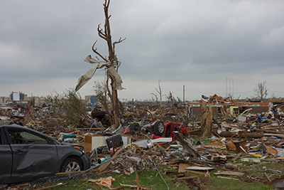
The team spent the most time in the very large residential area that was decimated by the event. This area also contained the Plaza Towers Elementary School, where nine children lost their lives. The destruction went on for blocks, and since the tornado was at its widest here (1.3 miles), the number of leveled homes, the number of damaged homes—of all severities—was considerably higher.
The area was characterized by a variety of construction types, including wood frame, brick, masonry, and concrete. Wood frame construction was clearly the most vulnerable (see Figure 8).
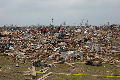
For masonry, brick, and concrete construction, most of the damage sustained was to roofing and cladding (see Figure 9). Overall, the degree of damage in Site 5 was in a similar proportion to the other sites, i.e., the farther the building was located from the center of maximum wind field the less damage sustained (see Figure 10).

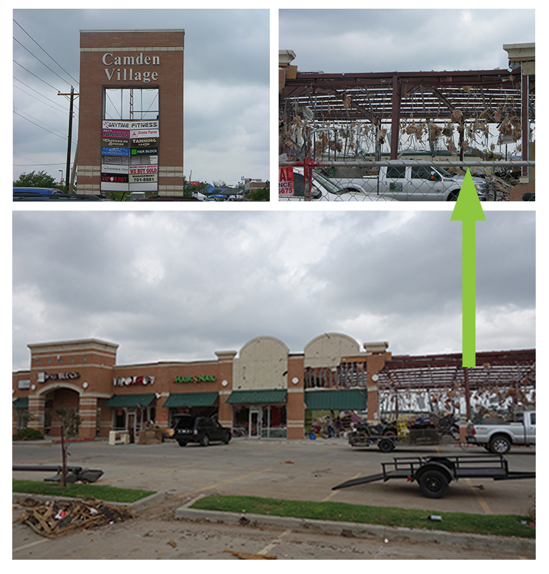
Strip Mall: Camden Village (Site 6)
The team next surveyed the Camden Village strip mall. The tornado dislocated the sign board (Figure 11) and completely tore away the roof coverings and large sections of the brick block and parapet walls, although the steel frames remained standing (Figure 11). There was also extensive damage to contents due to the falling ceilings, pieces of debris and other non-structural components, water leakage, etc.
Rural Areas Farther West (Site 7)
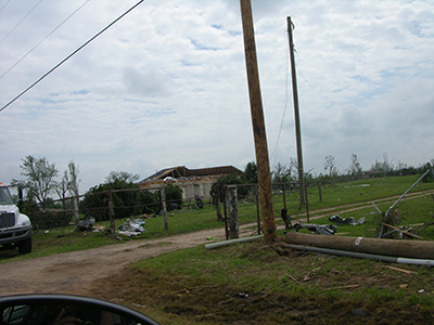
The team drove the length of the tornado track and concluded the survey at the touchdown point, near Site 7. Although the previous areas surveyed had the highest concentration of exposure, there were numerous homes destroyed farther west as well. In addition, there were several downed and buckled electric towers in this area. These caused power outages that resulted in business interruption for local businesses and impaired recovery efforts.
The survey provided practical insights into the cross-sectional wind profile of a rare EF-5 tornado, damage characteristics for various occupancy and construction types, and damage mechanisms of wind-borne debris and how far it can travel. Currently, AIR is working on the next version of its U.S. and Canada severe thunderstorm models, both of which are anticipated for release next year. The information gathered during AIR's post-disaster survey of the Moore tornado will be immensely helpful to the validation and calibration of the vulnerability functions in these updated models.
For information on AIR's collaborative effort with sister companies AER and Xactware to investigate the Moore tornado, click here.
