


The New Madrid Earthquake Bicentennial: Revisiting A Midwest Mystery
Dec 19, 2011
Editor's Note: This month marks the 200th anniversary of the first in a series of large earthquakes that took place in the heartland of the United States in the winter of 1811/12. AIR Director of Earthquake Hazard Dr. Mehrdad Mahdyiar and Dr. Paolo Bazzurro, AIR Principal Engineer and Director of Engineering Analysis and Research, describe the research community's current understanding of what happened and outline the financial implications of a recurrence. AIR would like to thank Robert A. Williams, Central & Eastern U.S. Earthquake Program Coordinator at the USGS, for his helpful comments on this article.
Most earthquakes occur where two or more tectonic plates come together. The most powerful earthquake to take place in the United States was the 1964 magnitude 9.2 Prince William Sound earthquake in Alaska—where the Pacific tectonic plate is subducted beneath the North American Plate. The best-known earthquake in America, the 1906 M7.8 San Francisco earthquake, took place along the San Andreas Fault—where the Pacific and North American Plates are grinding past each other as one plate moves to the north and the other to the south. The largest known earthquake anywhere in the world, the 1960 M9.5 Valdivia Chile earthquake, occurred where the South American Plate subducts the Nazca Plate.
But in the winter of 1811/12, a series of three large earthquakes violently shook the central Mississippi valley—some 1200 miles from the nearest plate boundary. Two hundred years later, scientists continue to struggle with the question of what caused those events and—more urgently—when they might happen again.
Winter 1811/12, New Madrid, Missouri Territory
In the winter of 1811/12, what seismologists today characterize as a "correlated triplet" of earthquakes struck the central United States. The first occurred on December 16th, with an estimated magnitude of 7.7; a second quake shook the region on January 23rd, with a magnitude of about 7.5; and finally on February 7th, again at a magnitude of about 7.7, a third earthquake struck.
The epicenter of the most widely felt of the three ruptures was in southeastern Missouri near the frontier trading settlement of New Madrid. Trees were uprooted and snapped in two, hillsides collapsed in landslides, and fissures opened and spouted out water, sand, and rocks. Along the Mississippi and its tributaries, river banks crumbled, new channels were formed and old ones cut off, entire islands disappeared, and the four-mile-long Reelfoot Lake came into being.
New Madrid was destroyed. In St. Louis, about 150 miles upriver and home at the time to 5,000 people, houses were severely damaged, while the tremors were felt as far as 800 miles away, in Washington, D.C. For many years, the belief persisted that the shaking caused church bells to ring in Boston, over 1,000 miles away. However, research undertaken in the last several years has clarified that bells did not ring in Boston, but rather in Charleston, South Carolina.
The area of most intense ground shaking stretched from Cairo, Illinois, to today's Memphis, Tennessee, an area comprising about 50,000 square miles. Parts of seven present-day states were directly affected: southern Illinois and southern Indiana, Missouri, Kentucky, Tennessee, and Arkansas, and northern Mississippi.

By: Dr. Mehrdad Mahdyiar and Dr. Paolo Bazzurro
Edited by Robert Zalisk
What Is Going On in the New Madrid Seismic Zone (NMSZ)?
Is the scenario of extensive destruction described in the box above realistic? The scientific consensus is that another New Madrid earthquake can indeed happen. But when might it occur?
A direct answer could be given if the answer to another question were known: What caused the New Madrid earthquakes 200 years ago? What was the seismic mechanism involved—and is it still at work today?
That answer is not known. However, several convincing theories have been put forward that have the virtue of being supported by some empirical evidence. All include the understanding that the NMSZ is a "failed rift," a place where about 600 million years ago the earth began to pull apart to form what normally would have become an ocean basin—but, for whatever reason(s), the process did not continue to completion.
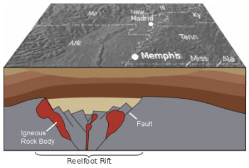
However, this millions-of-years-long "failed" development did produce numerous faults and other structural changes to the land, thereby weakening an extensive area of the lower crust and upper mantle below what today is the NMSZ. Geologists have determined the general outlines of this feature, which they call the "Reelfoot Rift."
Sometime in the ensuing eons, molten material from the lower mantle was injected into the weakened lower crust/upper mantle region, where it solidified into large deposits of dense igneous rock as identified by high-resolution seismic and geopotential imaging data (Figure 1).
The legacy of this geological history in the NMSZ is a complex and little-understood interaction between the earth's upper crust and a compromised lower crust/upper mantle. One interpretation is that the weak crust/mantle region undergoes periods of stress accumulation followed by episodes of relaxation. During the periods of accumulation, stress builds up on deeply buried faults in the NMSZ—eventually resulting in earthquakes—while the episodes of relaxation are characterized by low strain-accumulation rates at the surface. However, it has not been clearly established that periods of low measured strain at the surface coincide with periods during which no large earthquakes occur.
Faults in the NMSZ Reload
One set of theories suggests that, beginning about 20,000 years ago, rapid deglaciation (to which the crust is still adjusting) initiated seismic activity in the NMSZ; or possibly the subsidence of one of the especially massive igneous bodies is pulling down on the upper crust as it sinks; or that a remnant of the ancient Farallon Plate that was subducted 200 million years ago (where California is today) is only today, beneath the NMSZ, finally sinking into the mantle; and so on. These theories understand the underlying dynamic in the NMSZ as being one of constant stress, and that after the release of an earthquake, it begins again to accumulate—the fault "reloads."
Faults in the NMSZ Do Not Reload
A second set of theories, however, sees the NMSZ as being unaffected by any source of constant strain. The significance of this understanding is that, if correct, once an earthquake occurs, stress does not begin to build up again—the fault does not reload. This set of theories anticipates that the occurrence of large earthquakes in the NMSZ will decrease over time—a view given credence recently by GPS data that show very low rates of surface deformation in the region (less than 0.5 millimeters a year across the regional network). In one interview, the research group that gathered the GPS information (in 2009) went so far as to venture the possibility that the New Madrid system may be "shutting down." They also suggested that the stress might be shifted to other faults, but did not specify how far the stress shift would be.
Hazard Evaluation: The Dominant Uncertainties
Indeed, the GPS findings have engendered no little disagreement within the seismology community as to whether the present high level of earthquake hazard assigned to New Madrid by the current (2008) U.S. Geological Survey (USGS) national seismic hazard maps—which form the basis of the hazard component of the AIR U.S. earthquake model—is appropriate. Consequently, the National Earthquake Prediction Evaluation Council called for a review of the maps, and in April of 2011 the "Independent Expert Panel on New Madrid Seismic Zone Earthquake Hazards" issued its report.
The central finding of the Expert Panel was that "the New Madrid Seismic Zone is at significant risk for damaging earthquakes that must be accounted for in urban planning and development." The Panel added that USGS hazard maps "represent a reasonable consensus of the Earth Sciences community" at the time of the maps' development (2006 through 2008) and that they should continue to be used until the next generation of maps replaces them (planned for late 2013). At the same time, the Panel acknowledged that hazard in the region is sensitive to several geological parameters whose specific values and/or historical behavior remain uncertain. And perhaps most particularly, the Panel stated that a fundamental problem in estimating hazard is "the lack of knowledge concerning the physical processes that govern earthquake recurrence in the Central U.S."
The Expert Panel embraced the consensus view of New Madrid risk represented in the 2008 USGS maps largely because of the considerable body of data that establishes a record of historical and geological seismic activity in the NMSZ: specifically that the 1811/12 earthquakes were a recurrence and not an isolated event. Further, no theory or model adequately accounts for the possibility of all seismic activity coming to a sudden stop, although several theories based on recurring events do allow for periods of relative calm.
The chief uncertainties that remain are those reflected in the 2008 national seismic hazard maps, and they will likely be the same uncertainties that will be revisited in the 2013 effort. The three central problems—or "dominant uncertainties"—as identified by the Panel are: the recurrence rates of earthquakes in the NMSZ; the expected magnitudes of those earthquakes; and the expected ground motions that are generated. To this, however, should be added uncertainty in the location of the causative faults.
Uncertain Recurrence Period
Geological findings from ground surface deformations, paleoseismic and paleoliquefaction data, and recent studies of broken stalactites in caves in the region all establish a history of repeated earthquakes in the NMSZ. The understanding at present is that an event similar to New Madrid took place about 550 years ago (±100 years)—around the year 1450 CE—and that another happened in about 900 CE. Other recent evidence suggests that at least one large earthquake happened in about 300 CE.
Together, these dates suggest an average recurrence period of about 500 years. However, other recent studies have added complexities to these findings. One, for example, suggests that perhaps the northernmost segment of three proposed fault traces did not rupture in 1450 CE, which would indicate a return period of 750 years, not 500, for this segment. Yet another study of the course patterns of the Mississippi River suggests that a recurrence period of 1,000 years for the entire zone—a recurrence period that had been proposed with the release of the 1996 USGS hazard maps—was correct after all.
Uncertain Magnitudes and Fault Sources
The events of 1811/12 and earlier all happened before measuring instruments existed. Their magnitudes are therefore estimates based on comparisons with the physical effects of other more recent large earthquakes—effects such as the size of sand blows, stream offsets, vertical displacements or, in the caste of the 1811/12 events, written accounts of ground shaking, property damage, etc.
In the national seismic hazard maps published in 1996, the USGS modeled the earthquake rupture along three fault segments at once, and assigned the quake a magnitude of 8.0. By 2008, however, it was acknowledged that the 1811/12 series of earthquakes may not have been an anomaly and that large earthquakes in the NMSZ might typically occur in clusters of "correlated triplets"—as sequences of three ruptures that occur close together in time. Also, researchers had come to different conclusions concerning the magnitude of the 1811/12 sequence—but that all were of a lower magnitude than previously supposed.
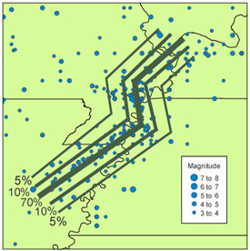
Figure 2 illustrates the USGS's current thinking about the location of the New Madrid fault segments, another extremely important parameter that has significant implications for the financial impacts of a recurrence of the event. Five possible locations are proposed, although heavily weighted to the central scenario (the weights assigned to each scenario are indicated on the map).
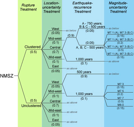
Thus, for the 2008 seismic hazard maps the USGS developed a consensus logic tree representation of New Madrid that captures the various possible magnitudes, fault locations, and recurrence periods. As shown in Figure 3, each scenario is weighted according to its likelihood of occurrence.
Uncertain Ground Motions
The amplitude, frequency content, and duration of ground shaking at any given site depend on several factors: the location of the rupture with respect to the site (including distance, depth, and orientation), the dynamics of the rupture, the materials through which the waves travel from the source to the site, and the soil conditions at the site.
For ground motion prediction equations (GMPEs) to reliably estimate ground motions at specific locations, the equations must be derived from recorded empirical data of past earthquakes that have similar characteristics. The data should be supplemented by science-based and analytical simulations that approximate those situations where data are scarce, such as ground motions at short distances from large earthquakes.
Instrumental data from the 1811/12 New Madrid earthquakes do not exist. Thus, the necessary equations appropriate to estimating hazard for the NMSZ can be derived only from the best available information from what are considered to be similar earthquakes that have occurred in a similar setting in other stable intraplate regions around the world.
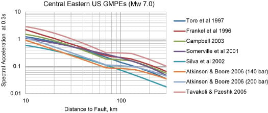
For the 2008 hazard maps, the USGS adopted an ensemble of GMPEs for use throughout the stable Central and Eastern United States. Figure 4 below shows the different predictions these equations provide for the median value of spectral acceleration (0.3 sec) generated at distances from 10 km to 300 km from an M7.0 earthquake. At a distance of 10 km (roughly 6 miles) the value of the median spectral acceleration as determined by the different GMPEs varies by a surprising factor of close to five (note the log scale of the axes). This factor represents significant uncertainty.
Even before the Independent Expert Panel Report highlighted ground motion as one of the three "dominant uncertainties" that constrain effective hazard estimates in the NMSZ, an effort had been launched by several federal agencies, including the USGS, to begin development of a new set of GMPEs for this region. The "Next Generation Attenuation for Central and Eastern North America Project," due for completion in time for the publication of the 2013 USGS seismic hazard maps, will benefit from having actual empirical data gathered from recent intraplate events that should be relatively similar to New Madrid: the M5.8 Mineral, Virginia, earthquake and the M4.7 and M5.6 Oklahoma earthquakes that occurred this year.
If 1811/12 Happened Today: Implications for the Insurance Industry
The USGS estimates that there is a seven to ten percent chance that an event like the one in 1811/12—that is, an earthquake having a magnitude of 7.0 or more—could occur within the next 50 years. What could the insurance industry expect if, in fact, the events of 200 years ago were to happen today?
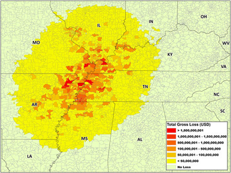
If we first consider our "best" understanding of what actually happened in 1811/12—by simulating those branches of the USGS logic tree associated with the highest weights and employing the USGS-recommended ensemble of GMPEs—AIR estimates that expected insured losses to residential, commercial and industrial buildings and contents would be on the order of $110 billion. Figure 5 illustrates the geographic distribution of these losses.
However, as will be evident by now from the discussion above, there is considerable uncertainty about what did happen in the winter of 1811/12 and how a future recurrence might play out. The AIR Earthquake Model for the United States enables users to simulate a wide range of scenarios representing the breadth of the USGS logic tree. The most benign of these (fault traces farthest from population centers, the lowest of the considered magnitudes, the most favorable depth, etc.) produces insured losses of about $40 billion. At the other end of the range, the most adverse scenario produces losses of nearly $400 billion.
A key benefit of the very large catalog of simulated events in the AIR U.S. earthquake model is the sensitivity testing it allows—testing that leads to a comprehensive understanding both of the uncertainties and sensitivities associated with the physical phenomena being modeled and with the model itself. Such an understanding can only lead to better risk management decisions.
