


Rethinking the Unthinkable: Modeling Unprecedented Ruptures Like the Great Tohoku Earthquake
Apr 25, 2011
Editor's Note: The Japan Trench—source of the M9.0 Tohoku earthquake—is one of the most seismically active subduction zones in the world and has a long record of strong earthquakes. Nevertheless, based on historical seismicity, scientists did not expect such a powerful earthquake in Japan's northeast region. In this article, AIR principal scientist. Bingming Shen-Tu and AIR director of earthquake hazard research Mehrdad Mahdyiar explore why the magnitude of the event, if not the magnitude of the loss, was a surprise and discuss its implications on future modeling of seismic risk in Japan.
The fifth strongest in recorded history, the March 11 Tohoku earthquake is redefining what seismologists consider "the Big One" for Japan. With a magnitude of 9.0, the rupture shook the earth for more than five minutes and resulted in 3-4 meters of vertical uplift of the ocean floor, generating a massive tsunami that engulfed the northeast coast of Honshu. Tide gauges recorded a maximum tsunami height of 7.3 meters and the waves overwhelmed coastal defense mechanisms, traveling miles inland in some areas and causing devastating destruction and loss of life.
According to Japan's Fire and Disaster Management Agency, more than 26,000 people are dead or missing as of April 22, 2011. Some 90,000 houses have been severely damaged or destroyed by tsunami and ground shaking, and a further 200,000 are partially damaged. AIR has estimated insured losses to property lines of USD 20-30 billion.1
An Earth-Shattering Rupture
The March 11, 2011 Tohoku earthquake is the largest to have occurred in the subduction zones around the islands of Japan. The main shock was preceded by a magnitude 7.2 foreshock, two days earlier and less than 40 km east. In the six weeks since, more than a thousand aftershocks have been triggered, about half of which have registered magnitude 5 or greater (exceeding more than 10 years of prior activity in this region). The largest aftershock, occurring 30 seconds after the main shock, was a magnitude 7.9 that ruptured a southern segment of the subduction zone fault.
In fact, the earthquake cascaded through several segments of the Japan Trench; the rupture zone is estimated at 450–600 km in length and 150–200 km in width. Based on seismic modeling results and GPS data, the horizontal movement along the plate interface is up to 25 to 30 meters near the epicentral area, representing roughly 400 years of accumulated strain. The sudden release of strain moved the coastal area of Miyagi prefecture eastward about 4 meters and downward more than 65 to 75 cm.
The earthquake generated a maximum recorded peak ground acceleration of 2.755g (2700 cm/s2). Among the 600 stations in central and northern Honshu, about 10% recorded 0.3 second spectral acceleration of greater than 1g. These short period seismic waves are most damaging to low-rise structures.

By: Dr. Bingming Shen-Tu and Dr. Mehrdad Mahdyiar
Edited by Nan Ma
High Historical Seismicity on the Japan Trench
The Tohoku earthquake occurred 130 km offshore east of Honshu Island in the Japan Trench subduction zone. Here, the Pacific Plate subducts under Japan at a convergence rate of about 8 cm per year, faster than most active subduction zones in the world where megathrust earthquakes have occurred in the last century. The fast plate motion rate and long history of subduction has sunk the oceanic Pacific Plate—which is among the oldest in the world—deep into the earth, penetrating into the upper mantle to a depth of over 600 km.
The Japan Trench is approximately 800 km long and is oriented in a generally north-south direction. It connects the Kuril Trench subduction zone to the north and the Mariana Trench to the south. Southwest of the Japan Trench, the young Philippine Sea Plate subducts under Japan at the Izu-Bonin Trench and the Nankai Trough (see Figure 1).
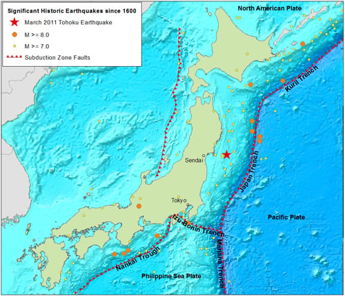
Prior to March 11, a total of 78 earthquakes of magnitude 7 or greater occurred on the Japan Trench in the last 400 years, close to two per decade on average. But earthquakes of magnitude 8 and above are very rare. Excluding the 1933 M8.2 Sanriku earthquake (which did not occur at the plate interface, but rather within the Pacific Plate), only one earthquake larger than magnitude 8 has occurred here in the last century. In contrast, other active subduction zones around the world—including the Chilean, Aleutian, Mexico, Kuril-Kamchatka, and Sumatra trenches—have experienced a much higher incidence of these larger temblors.
Unforeseen Risk
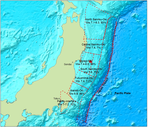
In 2005, Japan's Headquarters for Earthquake Research Promotion (HERP) released the first national seismic hazard maps (subsequently updated in 2006 and 2007), which represent the consensus opinions of a large committee of leading seismologists in Japan. HERP divided the Japan Trench into six segments and eight seismic source zones (see Figure 2) and assigned maximum expected magnitudes of 8–8.3 in the northern zones and <7.5 in the two southern zones. These represent the characteristic earthquakes, which are large recurring earthquakes that define the source zones. The characteristic earthquakes on the Japan Trench were assigned return periods that range from 15.5 years to 400 years.
In the HERP report, three of the eight source zones were assigned a probability of 79% or higher of a characteristic earthquake occurring within the next 30 years (with associated magnitudes ranging from 6.8 to 8.3). The Miyagi-Oki segment, from which the March 11 Tohoku earthquake initiated, was assigned a 98% probability of rupture with M≥7.4. Thus, seismologists were well expecting a large event to occur on the Japan Trench, albeit of a much lower magnitude (as a point of comparison, a magnitude 9 earthquake releases approximately 30 times more energy than a magnitude 8). Furthermore, cascading rupture scenarios—in which multiple adjacent segments rupture simultaneously—were not considered in the modeled source zones of the Japan Trench, except in the two zones east of Miyagi (Miyagi-Oki and South Sanriku-Oki) where there is evidence of past two-segment ruptures.
The 2011 Tohoku earthquake far exceeded the largest expected earthquake on the Japan Trench in the HERP maps. While the reasons behind their modeling scheme were not detailed in the published report, it is known that HERP heavily weighted historical seismicity data in developing seismic hazard maps for all trenches surrounding Japan's islands. The view of fault segmentation, characteristic earthquake magnitude, recurrence rate, and cascading ruptures were all based mostly—if not exclusively—on historical data. The justification is discussed in the next sections.
No Precedence in Japan's Long Earthquake Record
The record for significant earthquakes in and around the main islands of Japan is believed to be complete since 1600, although written records of the most severe quakes date back to the late 7th century. The earliest recorded earthquake in the Tohoku region occurred in 869 with an estimated magnitude of 8.6. Another one in 1896—with an estimated magnitude of 8.3–8.5—occurred on northern part of the Japan Trench. This earthquake generated the largest tsunami in the known history of the Tohoku region and caused more than 26,000 deaths.
Table 1. Number of large historic earthquakes in the Japan Trench
| Magnitude | Total Number of Events Since 1600 | Number of Events Since 1900 |
| ≥7.0 | 78 | 43 |
| ≥7.5 | 21 | 9 |
| ≥8.0 | 4 | 1 |
Japan's 400-year complete historical record is much longer than the return periods of characteristic earthquakes along most segments in the Japan Trench. The frequency of significant earthquakes along the Japan Trench is quite high and most fault segments have experienced more than two seismic cycles in the last 400 years. Accordingly, HERP's seismicity model assigned return periods of 134 years or less to five of the six segments along the Japan Trench. The exception is the Fukushima-Oki segment, which was assigned a return period of 400 years because of its lack of large historical earthquakes.
HERP's national hazard model is time-dependent, meaning that the probability that an earthquake will occur in the coming year increases with the length of time elapsed since the previous event. Constructing a time-dependent model requires knowledge both of the time since the last rupture and of the mean interval between past ruptures (as well as a probabilistic model to capture the stochastic nature of the rupture intervals). Missing either of these greatly increases the uncertainty, making the model speculative and less objective.
While a historical record of two to three times the characteristic earthquake return periods is not long enough to reliably estimate the return periods of characteristic earthquakes, there is far greater uncertainty in attempting to model a cascading rupture scenario like the March 11 earthquake that has never occurred in history. To consider this type of scenario, assumptions would need to be made regarding both the return period and the elapsed time since the last rupture. Although it is possible to construct such scenarios based on information and assumptions on the plate convergence rate and the seismic efficiency of the subduction zone, lacking the historical data to support the assumptions significantly increases the model uncertainty.
Uncertainty in Understanding Seismic Coupling
Because the historical record is less complete for large magnitude events, regional earthquake hazard models are often supplemented with paleoseismic data (geological evidence of prehistoric earthquakes) and geodetic data (GPS measurements of crustal deformation along fault zones) to better estimate recurrence intervals. This type of information was crucial in modeling the return periods of characteristic earthquakes along most crustal faults in Japan.
However, for subduction zones including the Japan Trench, fault slip rates and moment rates were not directly used in the construction of the seismicity model. Several studies of the Japan Trench found that despite the high historical seismicity, past earthquakes from the last 400 years released only a small fraction of the total energy accumulated due to plate motion. This large energy deficit, if it is to be released seismically, suggests the possibility of much larger earthquakes that are not consistent with the known historical record. That HERP did not consider this in modeling the Japan Trench can be attributed to uncertainties in the current understanding of seismic coupling.
Seismic coupling refers to the degree to which two sides of a fault are locked and accumulating stress, which is a major determinant in the ability of a subduction zone to produce mega-earthquakes. Seismic coupling along major subduction zones has been estimated to range from less than 1% (uncoupled) to 100% (fully coupled). Some scientists attribute this wide variation to the short historical record relative to the return periods of large earthquakes, while others suggest that coupling is a long-term property of each subduction zone based on unique physical and mechanical properties (including age, thermal status of the subducting plate, plate motion velocity, and roughness of the plate interface).
Based on historical seismicity data, the seismic coupling on the Japan Trench, calculated as the ratio between the energy released by earthquakes to the total energy accumulated from fault slip and plate motion, has been estimated to be weak at <10–25% (Kanamori 1977, Pacheco et al. 1993). In addition, the trench lacks historical megathrust earthquakes and evidence of large asperities (or locked regions) that characterize many nearly fully coupled subduction zones like the Chilean, Kamchatka, Aleutian, Sumatra trenches. As a result, some scientists had suggested that the majority of seismic energy accumulated in the Japan Trench is released aseismically—by fault creep or through "slow earthquakes" (e.g., Kawasaki et al, 2000).
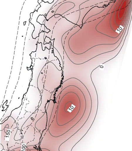
Researchers using geodetic data to compare fault slip rates with the long-term convergence rate found evidence of higher coupling than suggested by historical seismicity. For example Mazzotti et al. (2000), using GPS data collected between 1995 and 1997, concluded the Japan Trench may be fully coupled. El-Fiky & Kato (2006), using denser and more recent (1996–2000) GPS data including vertical measurements, calculated an average coupling coefficient of 50%, which is consistent with the results from a century of geodetic data on Honshu Island obtained by Shen-Tu (an author of this AIRCurrents article) & Holt (1996). Other researchers (e.g. Nishimura et al., 2004; Suwa et al., 2006) have shown that the degree of coupling along the Japan Trench varies from 25% to 100% (see Figure 3). The Miyagi segment, where the March 11 earthquake initiated, was found to be strongly coupled.
The results from historical seismic data (weak coupling) and geodetic data (strong coupling) are clearly inconsistent and have significantly different implications for seismic risk assessment in the region. In this complex subduction zone, this large uncertainty makes any model that considers multiple fault segment ruptures without the support of historical data very subjective and challenging. The debate is now over—that is, the Tohoku earthquake was de facto proof of the existence of significant coupling. Indeed, accounting for the seismic moment from the March 11 earthquake sequence (and assuming a recurrence interval of 1,000 years or shorter) results in a seismic coupling coefficient close to 50%, consistent with the results from El-Fiky & Kato and Shen-Tu & Holt. Before March 11 however, the uncertainty was deemed too large to justify its incorporation in seismic hazard models.
Concluding Thoughts
One area of keen interest is the potential effect of the Tohoku earthquake on nearby faults and subduction zones and, in particular, on subduction zone segments closer to Tokyo. While it is known that the occurrence of a large earthquake changes the stress on nearby faults, calculating these unseen subtle shifts and deformations under the ground and translating them into rupture probabilities is a daunting task.
At this very early stage, Toda et al (2011) in a joint effort between the USGS and Kyoto University have provided a preliminary qualitative indication of the increase or decrease in stress on nearby faults. While they refrain from quantifying potential changes to rupture probabilities, their results show that the southernmost segment of the Japan Trench (the Kanto fragment) and the Itoigawa-Shizuoka Tectonic Line, both close to Tokyo, were brought closer to failure by the March 11 event. The impact on the Nankai Trough, which has received the most attention in Japan because of its large potential impact to Tokyo, was minor. It is important to emphasize, however, that these findings are still quite preliminary.
AIR will continue to study the causes and effects of the devastating March 11 earthquake and its implications on regional seismicity. Thanks to Japan's dense seismic monitoring network, the event is the best-recorded mega-earthquake and one that will be the focus of much research for decades to come. One important implication is that seismologist will have to reconsider the approach to modeling rupture scenarios that have no historical precedence. Much like 2008 Wenchuan earthquake in China, the Tohoku earthquake has once again shown that the historical records alone, even ones as long as Japan's, are not sufficient to model the future risk of megathrust earthquakes. Although challenging from a risk estimation perspective, it is prudent within a probabilistic catastrophe modeling framework to account for physically plausible scenarios suggested by paleoseismic, geodetic, and other studies. Ultimately, however, companies exposed to catastrophe risk manage to various levels of loss, rather than to individual events. While it is not possible for a catastrophe model to perfectly capture the exact parameters of every future event, a well-constructed model will capture the full range of potential losses.
El-Fiky, G. and T. Kato (2006), Secular crustal deformation and interplate coupling of the Japanese Islands as deduced from continuous GPS array, 1996–2001. Tectonophysics, Vol 422, No 1–4.
Kawasaki, I., Y. Asai and Y. Tamura (2001), Space-time distribution of interpolate moment release including slow earthquakes and the seismo-geodetic coupling in the Sanriku-Oki region along the Japan trench, Tectonophysics, 330, 267-28
Mazzotti, S., X. Le Pichon, P. Henry, and S. Miyazaki (2000), Full interseismic locking of the Nankai and Japan-west Kurile subduction zones: An analysis of uniform elastic strain accumulation in Japan constrained by permanent GPS, J. Geophys. Res., 105, 13,159 – 13,177.
Nishimura, T., T. Hirasawa, S. Myhazaki, T. Sagiya, T. Tada, S. Miura, and K. Tanaka (2004), Temporal change of Interplate coupling in northeastern Japan during 1995-2002 estimated from continuous GPS observations, Geophys. J. Int. 157, 901-916.
Shen-Tu, B. and W. E. Holt (1996), Interseismic horizontal deformation in northern Honshu and its relationship with the subduction of the Pacific plate in the Japan trench, Geophys. Res. Lett., 23, 3103–3106.
Suwa, Y., S. Miura, A. Hasegama, T. Sato, and K. Tachibana (2006), Interplate coupling beneath NE Japan inferred from three-dimensional displacement field, J. Geophys. Res. 111, B04402.
Toda, S., J. Lin, and R.S. Stein (2011), Using the 2011 M=9.0 Tohoku earthquake to test the Coulomb stress triggering hypothesis and to calculate faults brought closer to failure, submitted to Earth Planets Space, 7 April 2011, 17.
1 AIR's estimates reflect insured physical damage to property (residential; commercial/industrial; mutuals and cooperatives, both structures and their contents resulting from shake, fire following and tsunami. They do not include losses from other non-modeled perils, including landslide; losses to automobiles, land, casualty and life lines; direct and indirect business interruption; losses to infrastructure and insured properties; loss adjustment expenses, or demand surge.
