


1868: The Original Great San Francisco Earthquake
Nov 14, 2008
November 14, 2008
Editor's Note: Though often overshadowed in the public imagination by the well known San Andreas Fault to the west, the Hayward Fault is an equally well studied fault in the San Francisco Bay Area, and one that is capable of producing large magnitude earthquakes akin to its more famous cousin. According to estimates by the US Geological Survey, stress on the Hayward fault is released cataclysmically in the form of a major earthquake approximately every 140 years. The last such event occurred on October 21, 1868—140 years ago. With dramatic flair uncharacteristic of the profession, scientists have labeled the Hayward Fault a tectonic time bomb, due at any time to produce the next major Bay Area earthquake. In this article, AIR's Dr. Khosrow Shabestari and Dr. Tao Lai give an overview of the 1868 event, identify significant existing vulnerabilities and provide an estimate of the potential losses were the Hayward to rupture today.
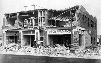
On October 21, 1868 at 7:53 a.m., a 6.8 magnitude earthquake shook the San Francisco Bay Area for forty seconds. It was the strongest in the region since written recordkeeping began in 1776 and was called the "Great San Francisco Earthquake" until the name was usurped by the far more damaging 1906 quake. A 20 mile segment on the southern end of the Hayward Fault ruptured the surface, roughly from Fremont to San Leandro, although the deep rupture beneath likely extended up to Berkeley, another 15 miles away. The average horizontal strike-slip displacement of the fault was around 6 feet, while the crack that opened at the surface averaged 6 inches wide.
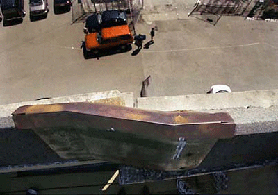
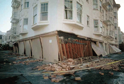
Although the area was sparsely populated at the time, the earthquake remains one of the most destructive in California history, causing damage as far away as Napa to the north and Hollister to the south (some 130 miles apart). The East Bay towns immediately above the fault suffered extensive damage. In Hayward, a town of then about 500 residents, almost every building was severely damaged; most were knocked off their foundations and rendered uninhabitable. Nearby San Leandro and Fremont, north and south of Hayward, experienced slightly milder shaking. Still, many brick, adobe, even some wood-frame structures were severely damaged.
Further away in the much larger cities of Oakland and San Jose, many chimneys toppled and some brick buildings were damaged. Notably, shaking was intense across the Bay in parts of San Francisco, which suffered an estimated $350,000 in property damage (in 1868 dollars)—by far the highest concentration of both exposure and loss. Buildings constructed on reclaimed landfill in the Bay fared especially poorly. In total, thirty people were killed.

By: Dr. Khosrow Shabestari and Dr. Tao Lai
Tectonic Setting and Recurrence Potential
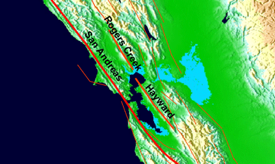
The Hayward Fault extends approximately 50 miles through the East Bay region, from south Fremont into the San Pablo Bay. In perhaps its most dramatic manifestation, the fault runs longitudinally down UC Berkeley's football field, Memorial Stadium, displacing the walls at the north and south ends by as much as 13 inches. Elsewhere, the fault is evident in offset curbs, cracked asphalt, and damaged building foundations.
The Hayward Fault runs along the base of the East Bay foothills, parallel to the San Andreas Fault, and belongs to the greater San Andreas system. The San Andreas Fault marks the transform boundary between the Pacific Plate, moving toward the northwest, and the North American Plate, moving toward the southeast. As they move, stress generated on either side creates additional faulting. The Hayward Fault was formed in this manner tens of millions of years ago. Like most earthquake faults in the region, it is a right-lateral strike-slip fault; that is, facing the fault from either side, the opposite side moves to the right.
Geological monitoring and satellite data reveal that the two sides of the fault are aseismically "creeping" past each other at the surface at a rate of about 1/5 inch per year. This movement, however, does not extend the entire depth of the fault plane and thus is insufficient to relieve the accumulating strain. The long-term movement of the fault is far greater than the average surface creep, meaning that major earthquakes account for the rest of the movement.
Excavations along the Hayward Fault have revealed evidence of twelve major earthquakes. The last five, which occurred during the period 1315 to 1868, have stuck at intervals ranging from 95 years to 160 years, with an average interval of 138 years. Because it has been 140 years since the 1868 quake, scientists believe that the next one may be due.
In fact, scientists at the USGS estimate that there is about a 30% probability of a magnitude 6.7 or greater earthquake occurring on the Hayward Fault in the next 30 years, the highest for any single fault in the Bay Area. The expected magnitude is between 6.8 and 7.0, although larger quakes are possible, particularly if the rupture extends into the Rodgers Creek Fault, the segment adjoining to the north.
The Bay Area's Vulnerable Buildings
Today, more than 7 million people reside in the Bay Area's nine counties, about 25 times greater than in 1868. Over the past century, the silver lining in California's history of damaging earthquakes has been the implementation of some of the strictest building standards in the world, as seismic codes and construction practices were improved after each successive quake.
The notable exception was the 1906 San Francisco earthquake, after which building standards were actually lowered in the rush to rebuild the city, in part in preparation for the 1915 World's Fair but even more importantly, to avoid the perception that the region was unfavorable to business because of earthquake risk. This lack of prudence and the rapid urbanization of the Bay Area suggests that the buildings that still exist from that period may pose a significant threat to this day. In fact, in the next major Bay Area quake, the majority of building failures and human casualties will be caused by the failure of a small percentage of the building stock—namely, buildings that exhibit deficiencies, including but not restricted to those discussed below.
It should be noted that most building codes are formulated to provide a measure of safety against collapse, thereby mitigating the chances of serious injury or death. However, from an insured loss perspective, buildings designed according to code can still sustain significant damage during an earthquake, making them economically unviable to repair; thus, even cases of partial collapse would be treated as complete insurance losses.
Unreinforced Masonry
Many buildings constructed prior to 1933 were unreinforced masonry structures (URM), which are so named because their masonry walls—usually brick, but sometimes stone, hollow tile, concrete, and adobe—lack the strengthening reinforcement of embedded steel bars. The poor seismic performance of URM is attributed to their brittleness or lack of ductility, heavy weight and the lack of a lateral resisting system (which is in turn due to the lack of tensile strength in the mortar holding the masonry together), and absence of proper anchorage of the walls to the roof and floor. During an earthquake, the URM walls can easily crack, crumble and separate, gradually losing their bearing capacity and leading to collapse when subjected to longer or strong shakings. New URM construction was prohibited after 1933 because of the high incidence of collapse observed in the Long Beach earthquake.
In 1986, California passed the "URM Law," requiring local Bay Area governments to create an inventory of URM buildings, establish a loss reduction program for these buildings, and update the California Seismic Safety Commission (SSC) of retrofitting progress. The first widely used technical standard for retrofitting URM buildings was established in the 1991 Uniform Code for Building Conservation. According to the SSC, as of 2004, the nine Bay Area counties have around 6,500 URM buildings, roughly half of which are in the cities of San Francisco and Oakland. Over 70% of URM buildings have been retrofitted in San Francisco and Oakland; over the entire Bay Area, the proportion is around 50%.
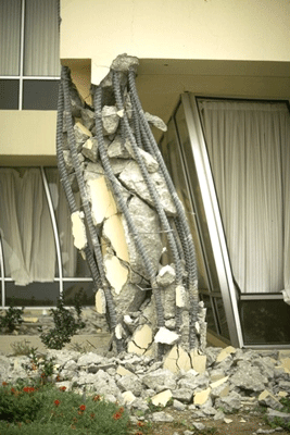
Nonductile Reinforced Concrete
After the construction of URM buildings was prohibited in California, reinforced concrete (RC) structures became popular. Until 1971, these structures remained largely untested by strong ground motions in the United States. Seismic design in the 1950s and 1960s focused on strengthening the structural components of the building to resist lateral forces. However, after the 1971 San Fernando earthquake, structural engineers determined that a high incidence of RC building failure was caused by detailing deficiencies in joints, beams, and columns. These pre-1970s RC buildings are considered nonductile because of their limited ability to deform, and thus withstand, strong earthquake forces. The 1976 Uniform Building Code introduced the first provisions to improve the ductility of these structures.
At present, it is unknown how many of these structures exist in the Bay Area; the SSC estimates that there are 40,000 throughout California. Because of the difficulty in identifying these high risk structures and the cost of retrofitting them, there is currently no code or legislation to explicitly mitigate this threat.
Wood-Frame Multifamily
The greatest vulnerability in the next Hayward quake arises from multifamily wood-frame buildings. According to the Earthquake Engineering Research Institute (EERI), one in six of such buildings in the Bay Area have soft stories in the form of large open spaces on the ground floor, commonly used for parking or commerce. They lack adequate shear walls to distribute lateral forces during earthquakes, making the soft stories weak and prone to large deformations and possibly collapse during earthquakes. Many of these buildings were built after WWII, when construction of on-site parking was often required for residential properties. In many older buildings, the ground floors had been converted for this purpose.
The EERI estimates that over half a million Bay Area residents live in buildings with a vulnerable soft story. They are especially prevalent in San Francisco, where they account for 70% of multifamily buildings. Soft story construction was banned in the 1970s, but few have been retrofitted since then and no mandatory retrofit programs have been adopted. According to the Association of Bay Area Governments, almost half of the 16,000 housing units rendered uninhabitable in the Loma Prieta $earthquake and two-thirds of the 46,000 units rendered uninhabitable by the Northridge earthquake were in buildings with soft stories.
Managing California's Earthquake Risk
Will the 1906 Great San Francisco Earthquake be supplanted in turn by a recurrence of the 1868 Hayward Earthquake? What would the losses be from such an event? Many estimates have been released in light of the earthquake's 140th anniversary—and of course there is no one "right" number. The next event on this fault is unlikely to be the same as the 1868 event. When we account for the possible variations in magnitude, the location of the epicenter along the fault, and whether the entire fault ruptures or only a single segment, or whether the Rodgers Creek Fault is involved, we get a distribution of losses (of course, there are many other variables as well, such as the direction of rupture).
The distribution in Figure 6 shows the range of possible losses generated by the AIR Earthquake Model for a rupture of the Hayward Fault. The ground-up property losses (excluding infrastructure and lifelines) range from roughly $100 billion to roughly $400 billion, while the magnitude ranges from 6.6 to 7.4. The mean scenario affects about $2.0 trillion in insurable property and causes a ground up loss of about $209 billion, including the effects of demand surge.
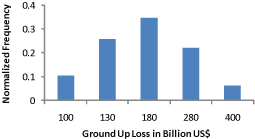
Note that these estimates reflect physical damage to insurable properties based on the latest AIR industry exposure database as of the end of 2007; only a fraction of the loss is expected to be paid by the insurance industry.
While deterministic simulations such as the ones being carried out for a repeat of the 1868 Hayward Earthquake, as well as the Great Southern California ShakeOut event explored in the September issue of AIR Currents are important in the effort to raise public awareness—particularly in an at-risk state where it is estimated that only about 12% of households carry earthquake insurance—they are not particularly useful from a risk management standpoint. According to a recent study released by the US Geological Survey, the chances of one or more earthquakes of magnitude 6.7 or larger in California in the next 30 years are 99%. The chances of a M7.5 or larger in the next 30 years are 46%. The crux of the matter, however, is that exactly where and when will such an event or events will happen is unknown. While the Hayward Fault is certainly a candidate, there are many other faults across California capable of producing large losses—and indeed there are undoubtedly faults that are still undiscovered and will remain undiscovered until they rupture.
It is exactly this uncertainty that probabilistic catastrophe models are designed to address, not only in assessing seismic hazard, but also in assessing the likely response of the existing building inventory to earthquake ground motion and the fires that will surely follow. While California's seismic codes are among the best in the world, large losses are not only possible, they will occur. By embracing uncertainty and assessing the probability of loss in a holistic sense, catastrophe models provide insurers, corporate risk managers and government entities the information they need to fashion risk management strategies that will better prepare them, their clients and constituents for the inevitable.
