


Mapping the 2013 Floods in Central Europe
In late May 2013, a pronounced and persistent jet stream pattern stalled two low-pressure systems over Central Europe. Fed by a steady stream of warm, moist Mediterranean air, the systems produced extreme rainfall over a period of several days. Parts of Germany, the Czech Republic, and Austria experienced the worst flooding since the Elbe Floods of 2002 (in certain areas, floodwaters reached their highest levels in more than 500 years).
The hardest hit was Germany, particularly along the upstream areas of the Danube and Elbe rivers. River dikes along the Elbe burst or threatened to fail, flooding hundreds of square kilometers in the east German states of Thuringia, Saxony, Saxony-Anhalt, and Lower-Saxony. Bavarian cities along the Danube River (Deggendorf and Passau in particular) suffered extensive damage. Rail lines between major cities such as Berlin, Cologne, Frankfurt, and Amsterdam were cut for days. In total more than 45,000 people had to be evacuated, and there were 22 reported fatalities.
 A flooded German town begins the recovery process. Note the water mark on the building. (Source: AIR)
 A swing set buried under feet of cement-like sediment. (Source: AIR)
A Multifaceted Approach to Estimating Damage
AIR takes a multifaceted approach to help clients understand the potential impact of this event on their own portfolios. Before the floodwaters had receded, reconnaissance teams were on the ground, and the flood modeling team released an insured losses estimate of between EUR 4.0 billion and EUR 5.8 billion for Germany using the AIR Inland Flood Model for Germany (visit the ALERT website for more details on AIR's loss estimates).
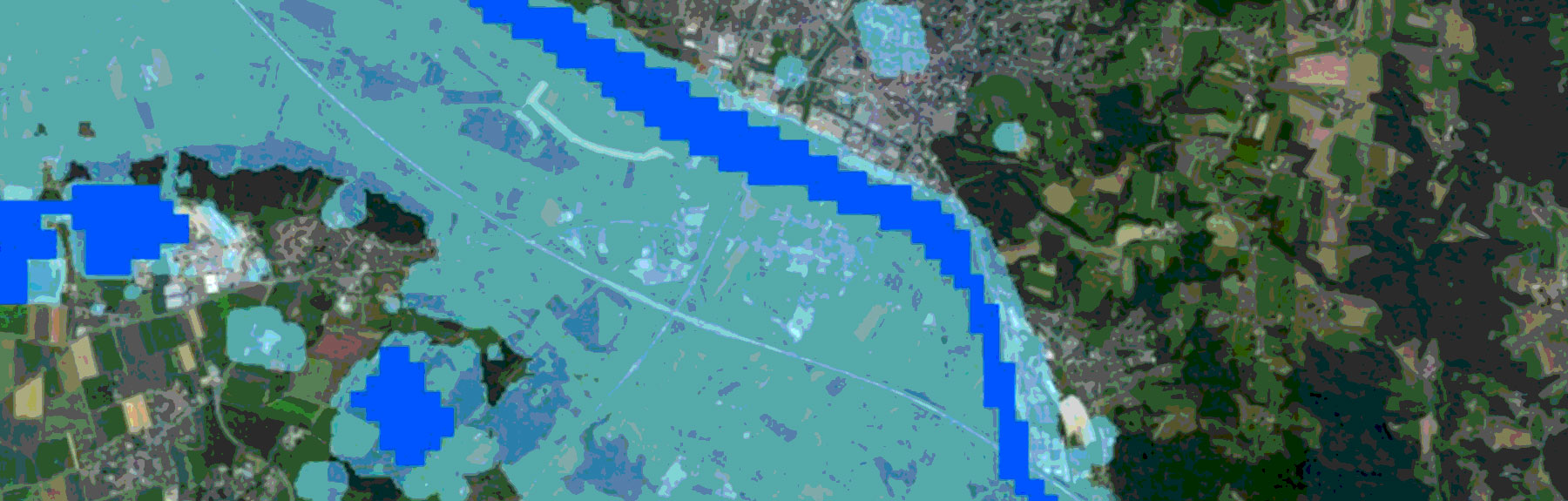
In addition, AIR mapped the maximum flood extent in Germany, Austria, and the Czech Republic and created a shape file that clients can import into Touchstone or other GIS-ready applications to understand how much of their exposure falls within the footprint.
To derive the maximum flood extent, AIR extracted and combined daily flood footprints using satellite imagery from the Moderate Resolution Imaging Spectrora diometers (MODIS) aboard NASA's Terra and Aqua satellites and, where available, the higher resolution Operational Land Imager on NASA's Landsat 8 satellite. This was supplemented with detailed flood maps from DLR (Germany's national space agency), which were available for certain urban areas in Germany.


In addition to the shape file (available to subscribers on the ALERT website), AIR published a set of maps that give a detailed view of flooded areas along some of the worst affected portions of the Danube and Elbe rivers in Germany.
AIR's satellite-derived flood footprint is used to validate the modeled flood extent, which is further ground-truthed with findings from the damage survey. Clients can import the shape file into Touchstone to assess their accumulated replacement value and exposed limits within the flood extent. Touchstone also allows users to apply user-defined damage ratios.
