


The 2018 Atlantic Hurricane Season has been relatively quiet—up until now. As this Blog is posted, Florence, once a Category 4 storm but now only a Category 2, is on the doorstep of the Carolinas. It will still bring damaging winds and significant storm surge, but also prodigious amounts of precipitation and inland flooding.
It is a given that hurricanes are characterized by high precipitation rates of several inches per hour. But for the second time in the last two years, hurricane precipitation in the U.S. will be exacerbated by incredibly slow movement at some point as Florence impinges on the Carolina coastline. In a blog last year I described Hurricane Harvey’s movement as “slower than people walk” and Florence will be moving at about that same speed—if not slower.
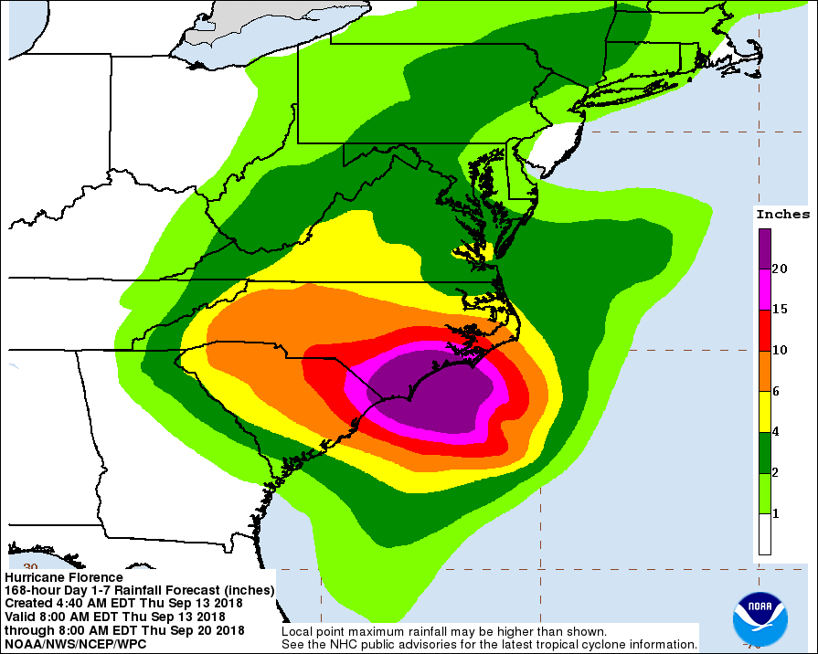
That sloth could translate into precipitation totals in excess of 30 inches in some places from South Carolina to Virginia. The records for hurricane generated rainfall in these states is 18.51 inches in South Carolina (from Jerry in 1995), 24.06 inches in North Carolina (from Floyd in 1999), and 27.00 inches in Virginia (from Camille in 1969). Each of these records may be broken by Florence—all by itself.
The record-breaking rainfall from Harvey in 2017, and what will likely be record rainfall from Florence 2018, can be partially explained by three factors, all tied to climate change:
- Decreasing forward speed. The decreasing forward speed of tropical cyclones over the last several decades has only recently been identified. One study (Kossin 2018) has shown a worldwide decrease of about 10% since 1949 and a 20-30% decrease in forward speed of storms over land. This slowing is believed to be linked to climate change. As the poles are warming faster than the tropics, the average pole-to-equator temperature difference is decreasing and large-scale weather systems are slowing down in response; decreasing forward speed of hurricanes, tropical cyclones, and typhoons may be the result.
- Increased precipitation. Also, let’s not forget that Harvey made landfall as a Category 4 storm and Florence was once at that same intensity category. Very warmer ocean waters obviously can— and do— contribute to such intensity, and the intensity can contribute to increased precipitation. Here’s why. Right at the surface, even over water, the rotational winds of a tropical cyclone deflect inward and ultimately upward because of friction. The frictional convergence is what contributes to the existence of the eyewall, where some of the heaviest precipitation in a storm falls. Increase the intensity and the convergence, rising motion, and precipitation increase too.
- More water vapor. Finally, related to the higher temperatures from climate change, is the fact that there can be more water vapor in the atmosphere; it is the strong rising motion in a hurricane eyewall that converts that additional water vapor into additional precipitation. The increase is about 7% for each degree Celsius of temperature increase.
Estimating the Average Impact of Climate Change
Because we have estimates for the impacts of climate change on forward speed reduction and for increased water vapor, for completeness let’s suppose that the impact on intensity (and therefore convergence) is 5%, which is what some published research has shown to be the case.
We can estimate the average impact that climate change is having on tropical cyclone precipitation to be 1.05 x 1.25 x 1.07 = 1.40, or about a 40% increase. That is just an average. That said, in the absence of any climate change, Harvey may have only generated 42 inches for a maximum instead of 60. And Florence would only generate 21 inches instead of 30 (the National Hurricane Center is forecasting 20 to 30 inches for Coastal North Carolina into far northeastern South Carolina, with 40 inches in places). And that is just an estimate of the climate change impact in 2018.
Can anyone imagine a stronger and slower version of Harvey later this century generating more than 80 inches? Can anyone imagine a stronger and slower version of Florence generating more than 40 inches? I can’t—but only because I can’t imagine anything moving more slowly than stationary. Hopefully, Florence will not do that, and will pick up the pace once she gets to the Carolinas.
For more on Hurricane Harvey visit “Hurricane Harvey’s Lasting Legacy: Flood”
