


2016 was the warmest year on record globally. In fact, each of the last three years broke the record set by the previous year, according to NOAA. While some studies have suggested that this continued warming of the Earth’s surface will eventually lead to an increase in the proportion of strong tropical cyclones, considerable uncertainty in this result remains, and the impact of a clear overall warming trend on the insurance industry is also somewhat ambiguous.
But what about the more immediate future, which, in light of the annual term of most insurance policies, is of more relevance to insurers? Season after season of hurricane activity and scientific advances in our understanding of tropical cyclones have shown that the factors influencing hurricane landfalls are much more complex than average surface warmth—or, for that matter, average ocean temperatures. It is tempting at the outset of another Atlantic hurricane season to try to extrapolate a picture of the season’s risk from recent climatic activity. Yet the complexity underlying landfalling tropical cyclone risk is the very reason that researchers at AIR have long advocated for a robust approach to estimating risk based on as many years of data as possible.
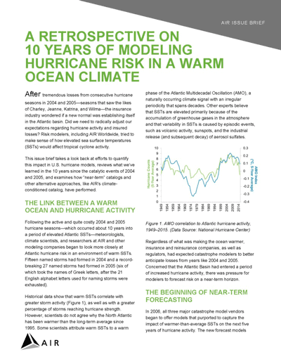
AMO and ENSO
In the Atlantic, sea surface warmth is captured by the Atlantic Multidecadal Oscillation (AMO). During the AMO’s positive phase, the North Atlantic Ocean surface is warmer than normal, and both basinwide and landfalling tropical cyclone activity tend to be elevated over their long-term mean values. The Atlantic is currently in a positive phase and has been since 1995.
However, a recent AIR study using machine learning to quantify the relative impact of large-scale climate variability on landfalls shows the AMO plays second fiddle to El Niño–Southern Oscillation (ENSO). During the El Niño phase of ENSO, this Pacific phenomenon has the long-range effect of enhancing vertical wind shear over the Atlantic, which hinders cyclone formation. This suppressed cyclogenesis tends to diminish the overall count of tropical cyclones that form in the basin during El Niño years. (The opposite conditions apply during La Niña years, in which basinwide activity tends to be enhanced.)
But, the somewhat capricious nature of ENSO means that predicting this oscillation’s phase even a few months in advance is often an exercise in forecast frustration. Case in point was the 2014 El Niño, originally forecast in late 2013 and then re-forecast in early 2014. It didn’t happen—until 2015. And then, it was the second largest ever after the 1997-98 one. Equally perplexing was the fact that a strong La Niña did not occur in 2016 like the strong ones that followed the two other big El Niño events in 1997-98 and 1982-83.
Inherent Variability
The most important take-away of our machine-learning study, however, is that the influence of climate signals on the probability of hurricane landfall is dwarfed by the inherent variability underlying the processes that form and drive tropical cyclones toward the coast in the first place.
In plain English, this means that even when apparently strong climate signals are in place, hurricane activity─to the contrary of expectations based on those signals─can occur. It’s easy to find examples from the historical record: Camille ’69 and Andrew ’92 both occurred when the AMO was negative; Charley, Frances, Ivan, and Jeanne all occurred in 2004─during a weak El Niño event. And the large amount of inherent randomness also reconciles the apparent paradox between the positive AMO we’ve been experiencing for the last two+ decades and the 10-year Florida hurricane landfall “drought” that only came to an end last year.
Our rigorous understanding of the interplay between climate and background randomness has always been the foundation for our consistent modeling approach at AIR. After all, catastrophe risk models are only useful as long as they can help users avoid the natural human tendency toward recency bias.
Read an update to the Association of British Insurers’ Research Paper No 19:
UK Windstorms and Climate Change


