


Earthquakes strike around the clock and around the globe, hitting some communities far harder than others. Developing resilience starts with a deep understanding of the perils faced, and that calls for resources that vulnerable communities often don’t have access to.
Seismic hazard maps, for example, show how earthquake hazards (measured as the likelihood of experiencing earthquake shaking of various intensities) vary across a region or country. The United States Geological Survey (USGS) describes its National Seismic Hazard Maps as “first and foremost a suite of products aimed at improving earthquake-resilient construction in the United States.” As well as forming the basis for building codes, seismic hazard maps can also be used to create mitigation strategies, loss models, and seismic hazard zones. They can be invaluable tools for insurers and reinsurers, government agencies, land use managers, and industries.
Wealthy developed nations have the resources needed to prepare national seismic hazard maps and then to update them periodically. Australia, for example, is currently reviewing a draft update of its national seismic hazard map, which was previously updated in 2012 and 1991. And in the U.S., the USGS National Seismic Hazard Maps are also currently in the process of being updated—which is now done every six years.
How Can Countries Most at Risk Develop Similar Tools?
We blogged a couple of years ago about the Global Earthquake Model (GEM), of which AIR is a founding member. As an independent non-profit, GEM works to provide catastrophe model access to communities traditionally priced out of the market. GEM’s OpenQuake (OQ) platform provides models, model components, and tools in the public domain. Researchers, modelers, and practitioners from all over the world can use the suite of tools in OQ to create catastrophe models similar to those developed by private firms such as AIR.
Scientific and financial contributions from companies like AIR are a key facet of the private-public partnerships needed to help developing countries better plan for, react to, and recover from natural catastrophes. Work supported by a Japan-World Bank Program that GEM and AIR are doing in partnership with the Georisk Scientific Research Company, Yerevan, Armenia, to develop a seismicity and hazard model for Armenia is a great example of what can be done.
Probabilistic Seismic Hazard Analysis for Armenia
The Republic of Armenia is a relatively small nation in the mountainous Caucasus region between Asia and Europe, surrounded by Turkey, Georgia, Azerbaijan, and Iran. According to the United Nations Development Programme, it is one of the 60 most disaster-prone countries in the world. It has a heightened risk of not only droughts and flooding but also earthquakes, as it lies within the central part of a large, 800-km wide, intracontinental collision zone between the Arabian and Eurasian plates, and regularly experiences temblors.
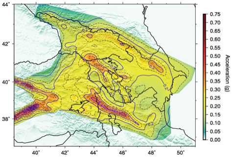
Following the devastating M6.9 Spitak earthquake of December 7, 1988, a national seismic zonation map was produced locally in the late 1990s, but there have been no official updates to it since then. GEM and AIR have together developed a new probabilistic seismic hazard analysis for the Republic of Armenia (SHARA17) and its surroundings. It uses the latest geological and paleoseismological information on active faults, strain rates from kinematic modeling of GPS data, and all available historic earthquake data. We also built a ground motion model using the latest, most relevant GMPEs, and accounted for the epistemic and aleatory uncertainties where possible. (Epistemic uncertainty results from an incomplete or inaccurate scientific understanding of the underlying process. In theory, as more knowledge or data becomes available, epistemic uncertainty should go to zero. Aleatory uncertainty, on the other hand, is a result of statistical variability. It is attributed to intrinsic randomness and is not reducible as more data is collected for a given model.) Details of the analysis will be presented at the 16th European Conference on Earthquake Engineering in Thessaloniki, June 18-21, 2018.
Local Ownership
GEM’s vision is to help form a more earthquake-resilient world. An important facet of GEM is that through its regional programs local experts become involved in their projects. Within this framework seismologists and engineers work together to build risk models, rather than focusing on their individual disciplines. GEM also helps build up capacity in less developed countries, and wherever possible local experts take ownership of, and responsibility for, risk estimates for their region. This is key to the effective use of risk models in these countries.
